KLAMATH COUNTY WATERFALLS
Lemolo
Lake, Crater Lake heading SE to Klamath Falls
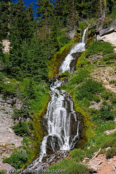
Vidae Falls
Elevation: 6715 feet
Latitude: 42.88442 N
Longitude: 122.1001 W
USGS:
Crater Lake 7 1/2
Height: 115' Width: 10'
Type: Tiered - 3 Drops
Source: Springs
Stream: Vidae Creek
Watershed: Klamath River
Best
Flows: Spring-Fall
Facilities:
* Roadside Access![]()
Information
This is the only publicized
of the three waterfalls in Crater Lake National Park. Vidae
Creek drains a very small area near the rim of the Crater
Lake caldera but is also fed by a very consistent albeit
somewhat low volume spring. Thanks to the high elevation of
the source there is always ample flow in the creek to make
the falls presentable. The falls splash over a
three-stepped bluff, dropping 115 feet before cascading
down a steep talus slope and flowing under the Crater Rim
drive. There is said to be another waterfall less than half
a mile downstream as well, but accessing it would be an
entirely off-trail endeavor.
Location
Drive to Crater Lake National Park, and proceed towards the
park headquarters along the Rim Drive. If you are coming
from SR 62, turn onto SR 209 and drive 3 1/2 miles to the
headquarters, then proceed along the rim drive for 3 more
miles to the falls. If you are coming from the north, all
you have to do is pretty much drive around the lake, and
you'll pass the falls.
Photo/Info: Permission of
Northwest
Waterfall Survey
![]()
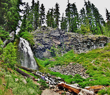
Plaikni Falls
Elevation: 6656 feet
Latitude:
42.90939 N.
Longitude: 122.04912 W
USGS: Crater Lake 7 1/2
Height- Width: Unknown
Falls Type: Unknown
Source: Springs
Stream: Sand Creek
Watershed: Klamath River
Best Flows: Spring-Fall
Facilities:![]()
![]()
![]()
Information
Plaikni Falls located on
the East Rim drive of Crater Lake. Photo taken from the
sign at the trail head - Plaikni Falls Trail: This route
winds through old-growth fir and hemlock forest, past a
series of rugged bluffs, to the base of Plaikni Falls.
Plaikni, a Klamath Indian word meaning from the high
country reflects the origin of the falls high on the slopes
of the volcano. The high country receives an average yearly
snowfall of 44 feet. Melting snow percolates through loose
volcanic soil, hits an impermeable layer, and surfaces as a
spring. One spring forms the origin of Sand Creek, which
cascades down as Plaikni Falls. In this lush environment,
mosses and wildflowers thrive.
Location
Drive to Crater Lake National Park, and proceed towards the
park headquarters along the Rim Drive. If you are coming
from SR 62, turn onto SR 209 and drive 3 1/2 miles to the
headquarters, then proceed along the rim drive for 3 more
miles to the falls. If coming from north, drive
around the lake to falls.
Photo by Francie S and Info by
Northwest
Waterfall Survey
![]()
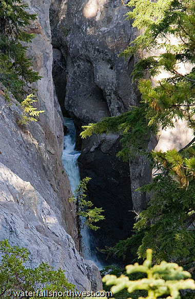
Duwee Falls
Elevation: 5950 feet
Latitude: 42.86445 N
Longitude: 122.14725 W
USGS:
Union Peak 7 1/2
Height: 100' Width: 15'
Type: Tiered
- 4 Drops
Source: Springs
Stream:
Munson Creek
Watershed: Klamath River
Best Flows: Spring-Fall
Facilities:![]()
![]()
Information
Duwee Falls is the largest
of the three officially named waterfalls in Crater Lake
National Park and it just might be the best waterfall in the
park altogether. The challenge, however, remains actually
seeing the falls to determine the accuracy of this
suspicion. The falls occur as Munson Creek snakes its way
down the side of Mount Mazama, cutting deeper and deeper
into a thick layer of petrified volcanic ash, finally giving
way as it reaches the head of Godfrey Glen. The falls start
off with plunges of about 15 and 40 feet, then appear to
cascade down two additional tiers of about 25 feet each. And
even though a wide, accessible trail passes within yards of
the top of the falls, nearly nothing can be seen due to the
narrow, twisted shape of the canyon. The best view is
actually a distant perspective from a pullout along Highway
62 near Mazama Village. Should access to the base of the
falls prove viable (it looked dicey if at all possible),
this might prove to be a very interesting waterfall.
Duwee is an adaptation of the Klamath Indian word "ti-wi",
meaning the sound of a rushing cascade or stream. The
original english spelling was Duwie, but when the name was
adopted by the USBGN, it was changed to Duwee.
Location
Duwee Falls is located near
Mazama Village in Crater Lake National Park. The best view
is from a pullout along Highway 62 about a mile south of the
entrance station at Mazama Village. The Godfrey Glen trail
also provides fleeting glimpses of the falls - the trailhead
for which can be found 1 3/4 miles north of the entrance
station (you will need to pay the entrance fee to access
this trail).
Photo/Info: Permission of
Northwest
Waterfall Survey
![]()
Annie Falls
Elevation: 5100 feet
Latitude:
42.81748 N
Lng: 122.11403 W
USGS: Maklaks Crater
Height: 53' Width: 20'
Falls Type: ?
Source: Springs
Stream: Annie Creek
Watershed: Klamath River
Best Flows: Year Round
Facilities: See Info.
Information
Annie Falls is one of three
named waterfalls in Crater Lake National Park. The falls
cascade 53 feet down a sloped step in Annie Creek Canyon,
surrounded by walls of petrified volcanic ash from the long
since gutted Mount Mazama. The falls are viewed from the
Annie Falls picnic area, but a grove of trees at the bottom
of the canyon obstruct the falls from view from pretty much
every angle in some way or another, and as a result, are
not a widely known or sought out attraction within Crater
Lake National Park. Do not try to approach the falls
closely - the canyon walls are extremely crumbly and
unstable, and a mis-step would almost certainly lead to
serious injury or worse.
Location
The Annie Falls picnic
area is 4 1/2 miles north of the south entrance to Crater
Lake National Park, along Highway 62, or 4 1/2 miles south
of the entrance station at Mazama Village.
Photo/Info: Permission of
Northwest
Waterfall Survey
![]()
Stuart Falls
Elevation: 5457 feet
Latitude: 42.79907
N
Longitude: 122.21276 W
USGS: Union Peak 7 1/2
Height-Width: Unknown
Falls Type: Unknown
Source: Springs
Stream: Red Blanket Crk
Watershed: Rogue River
Best Flows: Spring-fall
Facilities: Unknown
Information
Photo taken on June 8, 2013
of Stuart Falls. Looking for more Information
Location
Sky Lakes Wilderness
Photo by Francie S.
![]()
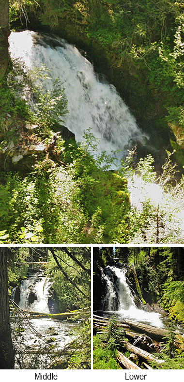
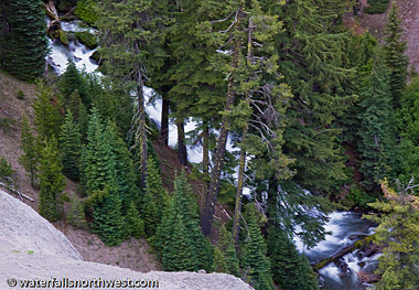
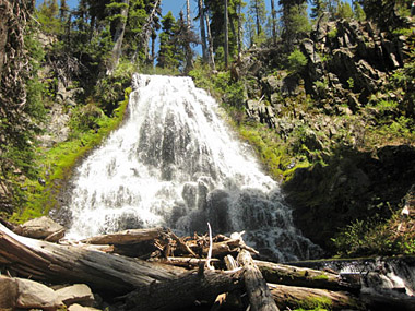
Red Blanket Falls
Elevation: 5002 feet
Latitude:
42.79306 N
Longitude: 122.22861 W
USGS: Union Peak 7
1/2
Height-Width: Unknown
Falls Type: Punch Bowl
Source: Springs
Stream: Red Blanket Crk
Watershed:
Rogue River
Best Flows: Unknown
Access: See Info.![]()
![]()
Information
Red Blanket Creek tumbles
out of the Sky Lakes Wilderness and flows west along the
southern boundary of Crater Lake National Park. A trail
along the north bank of the creek passes through stands of
Douglas fir and grand fir on its way to two named
waterfalls & several smaller unnamed.
Several factors combine to make the Red Blanket Creek Trail
refreshingly cool even on summer's hottest days. The trail
starts at an elevation of 3,900 feet, which guarantees that
the temperature will be at least 10 degrees cooler than the
valley floor. Dense tree cover keeps the sunshine off the
trail, holding down the temperature, and the chilly waters
of the creek itself cool the air too.
The trees
along Red Blanket Creek are notable enough to have earned
mention in "Best Old-Growth Forest Hikes, Washington &
Oregon Cascades," (Mountaineers Books, by John and Dianne
Cissel.) The Cissel's book has been described as the
"definitive guide" for finding outstanding old growth
forests in the Cascades by professor Jerry Franklin, an expert on old-growth
ecosystems.
Location
The trail begins just outside
the Sky Lakes Wilderness and climbs steadily for 2.9 miles
to Red Blanket Falls, the first of two named waterfalls on
the 4.3-mile (one way) trail. Red Blanket is a waterfall in
the punchbowl style, where the water descends through a
constricted passage to a pool.
People who are
content with a six-mile outing may call it a day at Red
Blanket Falls, but there's another waterfall farther up the
trail for those who are willing to add another 2.5 miles to
their trek. The trail continues past Red Blanket Falls to
Stuart Falls, where the creek spreads across an old lava
flow in a 40-50 foot fan. At this elevation hikers can see tree species such as Engelmann spruce,
western white pine and mountain hemlock. Note: Mosquitoes can be a problem in July.
To reach trailhead, take Highway 62 east from
Medford for 45 miles to Prospect. Turn right to "downtown"
Prospect and turn onto the Prospect-Butte Falls Highway at
the Prospect Hotel. Go one mile and turn left onto Red
Blanket Road; follow 11 miles to its end, where the
trail begins.
Photo by Francie S and Info by
Northwest
Waterfall Survey
![]()
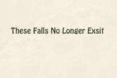
Klamath Falls
The Falls no longer
exist.
Previous Info:
Elevation: 4111 feet
Latitude: 42.23 N
Lng: 121.79917 W
Information
The actual Klamath Falls no
longer exist. They use to be located on the Klamath River
between Klamath Lake and Lake Ewauna.
A Bonus Picture!
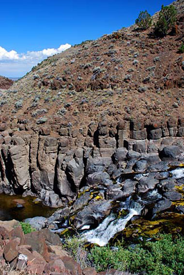
Deep Creek Falls
In Lake County
Elevation: 5457 feet
Latitude: 42.79907 N
Lng:
122.21276 W
USGS: Union Peak 71/2
Height-Width:
Unknown
Falls Type: Unknown
Source: Unknown
Stream: Unknown
Best Flows: Unknown
Information
As you travel through the
Warner Mountains from Lakeview to Adel, you will drive by
Deep Creek Falls. It is a beautiful picture in winter as
the water turns to ice. Some caution is needed when
stopping to observe the falls, which is located on a curvy
road with limited roadside shoulder for parking.
Photo:
Gary Halvorson, Oregon State Archives
![]()
BACK TO WATERFALLS
Add More Information!
We Can Add More Information to
this page, Click Here and supply
your text info and we will add it in!
Note: SouthernOrenon.com does not provide any
other specific directions or information by phone about
these Waterfalls or Parks, other than what is shown on the
pages.
This Waterfall page is used for general
informative purposes only. Visitors should verify these
locations, facilities and amenities before driving to these
remote region. This information on is
provided to users on an "as is" and "as available" basis without
warranty of any kind either express or implied. We are not responsible for any diving misdirections or info, if any, on this page. See terms page if needed.