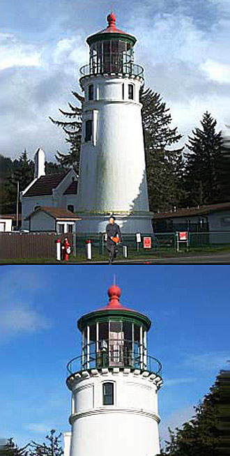
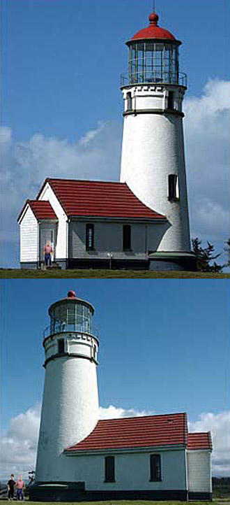
Umpqua River Lighthouse is located in
Douglas County on the Southern Oregon southwest coast on
Pacific Ocean. Construction
began in 1856, local Indians, who for centuries had used
the area as a prime hunting and fishing ground were none
too pleased to watch the progress.
On October 10,
1857, Keeper Fayette Crosby lit the third-order Fresnel
lens, the first light along the Oregon Coast. The
lighthouse was similar to others built at the time, a large
Cape Cod duplex with a tower rising from the gabled roof,
92 feet above ground. Unfortunately, the survey crew never
saw the site at flood stage, or the location may have been
different. Winter storms brought swollen river banks and
crashing seas. The lighthouse, built on sand, was
constantly battered. A coastal gale, on February 8, 1861,
along with a record mountain run off, combined to blast
away at the foundation. The foundation was eroded and the
house and tower tilted slightly. Another violent storm in
October 1863 added even more to the damage. Later, the
tower came crashing down.
In 1888, construction of
the second Umpqua River lighthouse. This time, with lesson
learned, it was built further inland on a headland above
the mouth of the river. The site is the furthest away from
a river or ocean of all the lighthouses along the Oregon
coast. Construction lasted from 1891 to 1894. The new
lighthouse is a 65-foot tower which stands 165 feet above
sea level. The tower, brick overlaid with cement plaster,
is 5 feet thick at the base and tapers to 21 inches thick
at the parapet. The lighthouse station included the tower,
two oil houses, two dwellings, and a barn. The light, a
first-order Fresnel lens manufactured in 1890 by Barbier &
Cie of Paris, using a Funck mineral oil lamp, was lit for
the first time on December 31, 1894, with a signature of
two white flashes followed by a red flash. The light was
automated in the 1960s and several of the outbuildings were
torn down. Before the light was automated, it was only lit
one hour before sunset until one hour after sunrise.
Curtains were drawn around the lantern room to protect the
lens from the sun.
Today the Fresnel light is still
shining. The lighthouse is part of the Umpqua River State
Park and is managed by Douglas County Parks, who host a
museum in one of the former Coast Guard buildings and
conduct tours of the tower during the summer months.
Call 1-800-551-6949 for more details.

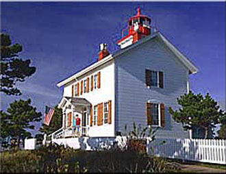
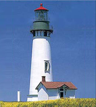
Yaquina Bay Lighthouse
Yaquina Bay is listed on the National Register of Historic
Places, and this lighthouse is believed to be the oldest
remaining structure in Newport. Yaquina Bay Lighthouse is
located in a state park at the north end of the Yaquina Bay
Bridge just a few miles south of the taller tower of
Yaquina Head. The Yaquina Bay Lighthouse was completed 1871
and stayed open for only 3 years. After along time of
neglect, it has been restored beautifully and in 1996 the
light was reactivated. (The original Fifth Order lens has
been long gone.) In the basement area is a great gift shop.
For more info call 1-800-551-6949
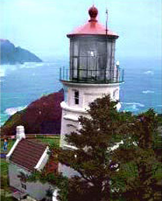
Heceta Head Lighthouse is located on the
central Oregon coast, 12 miles north of Florence, Pacific
Ocean. The area
was named after Captain Don Bruno de Heceta of the Spanish
Royal Navy. He was an explorer whose expedition passed
along the coast of Oregon around 1775. After nearly two
years and cost of $180,000, construction of this lighthouse
was completed in 1894. Bricks and cement from San
Francisco, stone from the Clackamas River, and wood from
Oregon mills were shipped to this site. This beautiful
lighthouse can be seen over 22 miles and from the Oregon
Sea Lions Caves. It is 205 feet above sea level. In order
to create a flat table on this rocky cliff, it took over
1,000 barrels of blasting powder.
Heceta Head State
Park is located in a cove at the mouth of Cape Creek. There
are picnic tables fantastic views the ocean. A nice trail
leads to the lighthouse and the lighthousekeeper's house. A
view of the coast north to Cape Perpetua can be seen as
well. Heceta Head trail offers beach and wildlife viewing
areas and is part of a 7-mile network. Sea lions, whales,
wildlife refuge, gulls and other sea life can be seen from
the trail, beach and cliff top lighthouse.
Fee based
for daily use or for annual permit for access to all state
park day use areas. For more info call
1-800-551-6949
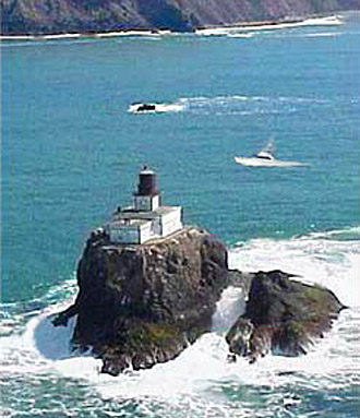
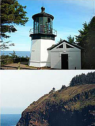
Tillamook Rock Lighthouse, on the Northern
Coast began in June 1879, a lighthouse engineer boated out
to the rock to determine if a lighthouse there would be
feasible. Though there were monstrous seas, and a landing
was impossible, the engineer decided the rock could be
conquered. An intriguing and powerful testament of the will
and determination of the human spirit. Knicknamed "Terrible
Tilly" All materials for the lighthouse were brought by
boat and hauled up the rock by derricks. The structure
originally was a one-story room, 48 x 45 feet with a 32 x
28 extension for the fog signal equipment.
Later a
half story was added. A 16-foot square tower rising from
the center of the building supports the lantern room and
parapet, which housed a first-order Fresnel lens (no longer
In). After a total of 525 days of labor, the lighthouse was
lit for the first time on January 21, 1881. The light shown
133 feet above the sea with a signature of a white flash
every five seconds. Terrible Tilly shone her light for 77
years. On September 1, 1957, Keeper Oswald Allik turned off
the light. The structure was gutted and turned into the
Eternity at Sea Columbarium. For more info Call
1-800-551-6949.
Photograph by Jason Wesley
Cape Meares Lighthouse is located atop a
217 foot cliff on the Northern Oregon Coast. Originally
named Cape Lookout by explorer Captain John Meares in 1788,
Originally, Cape Meares was named Cape Lookout by explorer
Captain John Meares, then renamed. Construction of the
lighthouse began in 1888. The first-order Fresnel lens was
shipped from France around Cape Horn to Cape Meares. A
hand-operated crane made from local spruce trees was used
to lift the crates containing the prisms of the one-ton
lens up the 200 foot cliff to the tower. The tower is made
of sheet iron lined with bricks, the only one of its kind
on the Oregon coast.
The light was lit for the
first time on January 1, 1890. Though the squatty
lighthouse was only 38 feet tall, located on a 217-foot
cliff, it could be seen for 21 miles. The light station consisted of the tower and
two oil houses. In 1895 a workroom abutting the tower was
added. Electricity came to the lighthouse in 1934, and the
two oil houses were dismantled. The lighthouse was
decommissioned in 1963 when an automated beacon was
installed on a concrete blockhouse a few feet from the
tower. The new light can be seen 25 miles at sea.
The lighthouse was opened to the public on Memorial Day,
1980. During the vacancy, the tower was subjected to
vandalism. All four bull's-eye prisms were stolen from the
lens. In 1984, one of the prisms was recovered in Portland,
Oregon and two more found their way back. For more info
call 1-800-551-6949
Yaquina Head, Oregon's tallest lighthouse
at 93 feet is located North of Newport, on the Central
Oregon Coast overlooking the Pacific Ocean at Yaquina Head.
Built in 1872 with over 370,000 bricks. A 1000 watt globe
has replaced the original oil wicks, and it now generates
over 130,000 candlepower. Yaquina Head Outstanding Natural
Area is the home of "Quarry Cove."
Lighthouses Of The
Oregon Coast. The lighthouse is open daily. There are
private tours available by calling the Bureau of Land
Management at 541-574-3100, Monday - Friday. Fees are based
per car, includes a three day pass. Call for Annual passes.
The Interpretive Store and the Interpretive Center
are open daily as well. The Interpretive Store phone number
is 541-574-3116. Contact Them For Hours &
Prices
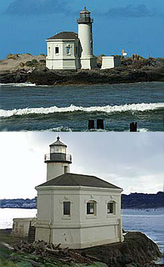
The octagonal, wrought iron tower was capped with a
lantern room housing a fourth-order Fresnel lens and was
supported by spindly metal legs. Located at the northern
end of the island, the tower was linked via a wooden
walkway to a one-and-a-half-story wooden keeper's dwelling,
constructed near the southern end of the island.
Rowboats were initially used to access the island, until a
low bridge to the island was constructed in 1876. However,
high seas cut short the bridge's life after just two years,
and the boats were a necessity once again.
In 1878,
a lifesaving station was established on the island, then it
was moved to the mainland in 1891, where it would be more
accessible. In 1889, there was construction of a more
robust high bridge to link the island to the mainland. In
1896, the Cape Arago Station received several improvements.
The existing light tower was encased in bricks and covered
with stucco. A brick fog building housing a Daboll trumpet
was constructed adjacent to the tower, and a new duplex was
built for the keepers.
When the fog signal had been
in operation for just over ten years, erosion on the point
endangered the lighthouse and fog building. A wood-frame
fog signal building with an attached octagonal tower was
built near the keeper's duplex. The light and fog signal
began operation on July 1, 1909. The new tower was similar
in appearance to the lighthouse that had been recently
constructed at Mukilteo, Washington.
In 1934, the
wooden lighthouse was moved a short distance to the east to
serve as the keeper's office, and Cape Arago's third
lighthouse was constructed nearby. Perhaps seeking a more
durable structure, the new lighthouse was constructed of
concrete, using the plans from Washington's Point Robinson
Lighthouse.
The only surviving structures on the
island today are the third lighthouse and the high bridge
constructed in 1889 to provide access to the island. The
original lighthouse was blown up with dynamite in 1936,
shortly after the third lighthouse was completed. The
keeper's duplex was razed in 1957, and the second
lighthouse met the same fate in the 1960s. The station was
automated in 1966. The Coast Guard removed the Fresnel lens
from the tower in 1993, and placed it on display at Coast
Guard Air Station North Bend. Call 1-800-551-6949
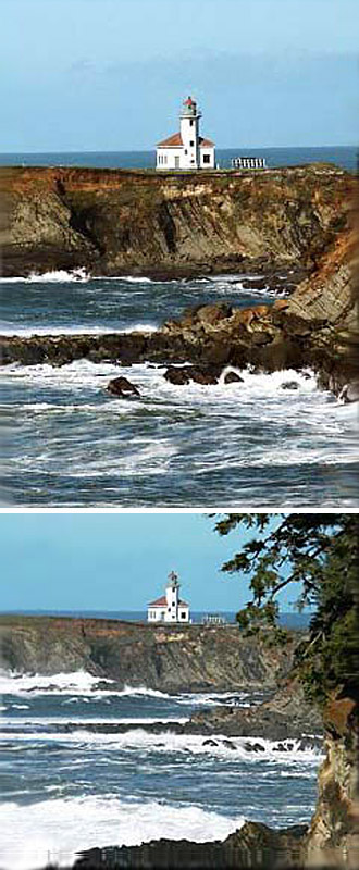
Coquille
River Lighthouse is located in Coos County on the Southern
Oregon coast, where the Coquille River empties into the
Pacific Ocean. It is adjacent to the town of Bandon. The
lighthouse was a logical step for improving navigation at
the river's mouth. The lighthouse would act as both a
coastal light and a harbor light. A bill authorizing its
construction was passed in 1891, but it would be four years
before land was purchased, plans were solidified, and the
construction crew arrived on site.
The workers first leveled the top
of Rackleff Rock to provide a base for the lighthouse and
oil house. Local stone was cut to form the structure's
foundation, while the lighthouse itself was built of brick,
covered with a layer of stucco. The design was unique with
a cylindrical tower attached to the east side of an
elongated, octagonal room, which housed the fog signal
equipment and had a large trumpet protruding from its
western wall. A long, wooden walkway connected the
lighthouse to the keeper's dwelling, 650 feet away. The
dwelling was a one-and-one-half story duplex, and a barn
was located 150 feet beyond the dwelling. The fourth-order
Fresnel lens was first shown from the tower on February 29,
1896. A snowstorm settled in the next day, necessitating
the first use of the fog signal.
In 1939 the
Coast Guard took responsibility for the lighthouse and
decided it was no longer needed. An automated beacon was
placed at the end of the south jetty, the dwelling was
disassembled, and the lighthouse was abandoned. The
lighthouse stood neglected for twenty-four years, until
Bullards Beach State Park was created on the north side of
the river. The grounds of the original 11-acre light
station were included in the park, and the park assumed
responsibility for the lighthouse. A joint restoration
effort involving Oregon State Parks and the Army Corps of
Engineers was launched in 1976. The roof was repaired,
bricks were replaced, and the lighthouse received a fresh
coat of paint before it was opened to the public. As part
of the Bandon centennial celebration in 1991, a
solar-powered light was placed in the tower. The lighthouse
is further illuminated in December, when it is outlined in
lights and plans also call for restoring the lantern room,
placing a fourth-order Fresnel lens in the tower, repairing
stucco, and installing a replica foghorn. For more info
call 1-800-551-6949
Cape Blanco Lighthouse is located near
Port Orford, on the Southern Oregon coast in Curry County.
Before construction of the lighthouse, the cape was covered
with a spruce forest. The trees had to be felled to prevent
obstruction of the light. Since the lighthouse was far from
any harbor, its primary function was to warn ships away
from the reefs, which extended from the cape, and to
provide a position fix for navigators. The light from a
powerful first-order Fresnel lens with a fixed, white
signature served this function well.
James Langlois
and James Hughes served the longest terms as keepers at
Cape Blanco, and during most of their terms they served
together. By the late 1890s, Hughes had two children and
Langlois five. The duplex was becoming crowded. The
inspector requested the construction of an additional
dwelling at the cape, but it took almost ten years of
requests before the new dwelling was completed in 1908.
Around 1910, a hood was placed around the lamp, and a
clockwork mechanism was used to raise and lower the hood to
produce a flashing signature. Between 1896 and 1916, more
than 4,0000 visitors signed the guest book. In 1936, the
original lens was replaced by a slightly smaller revolving
lens with eight bullseyes. The new lens was rotated by an
electric motor, powered by a generator. The motor and lens
are still operating in the tower today.
In 1980,
the lighthouse was automated. Twelve years later, two local
teenagers broke into the lighthouse and with a sledgehammer
smashed one of the lens' bullseyes and six smaller prisms.
The boys were eventually apprehended and convicted. After a
nation-wide search, Larry Hardin of Hardin Optical Company
in nearby Bandon was selected to repair the lens. By the
spring of 1994, the lens had been repaired using Corning
Pyrex, at a cost of $80,000.
On April 1, of 1996, the
station was once again opened to visitors. The two keepers'
dwellings, oil house, water tower, and other utility
buildings are all long gone, but the tower, the centerpiece
of the station, remains, and visitors are allowed to ascend
the spiral staircase to the lantern room, where the
repaired lens can be viewed.
* For Hours,
Fees, Directions & Tours for all lighthouses, call
the State Park Information Center directly at: 800-551-6949
( Unless Lighthouse has it's own number ).
Click Here For Other Attractions.