JACKSON COUNTY WATERFALLS
From
Prospect, Union Creek, Hwy 62, heading south to Medford &
Ashland.
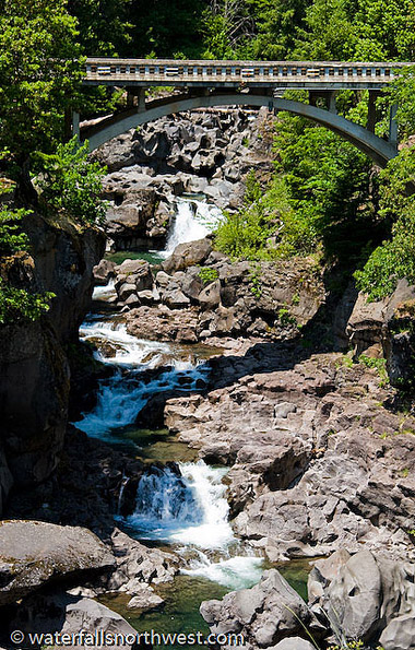
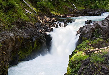
Prospect Falls
Elevation: 2469 feet
Latitude: 42.74556 N
Longitude:
122.49528W
USGS: Prospect S. 7 1/2
Height: 50' Width: 20'
Falls Type: Cascade
Source: Springs
Stream: Rogue River
Watershed: Rogue
River
Best Flows: Spring
Facilities
![]()
![]()
Information
Prospect Falls is a
moderate series of cascades long the Rogue River
immediately outside the small town of Prospect, south of
Crater Lake. The river drops through a chiseled wall of
block and slides and skips down a series of small steps
before petering into a long stretch of boulders, totaling
about 50 vertical feet in height. This waterfall would be
much more impressive if the Rogue River hadn't been
harnessed in a hydroelectric scheme just upstream of the
waterfall - because of which the flow of the river is
almost always greatly reduced and the falls are more of an
afterthought to the area. If you manage to visit when the
river is running at full force, this is a decent
attraction, but otherwise its worth skipping in favor of
the falls on nearby Mill and Barr Creeks.
PROSPECT FALLS is the Adopted name of this waterfall. To
the best of our knowledge this cascade has never been
officially named - the current title was coined in 1983 by
Greg Plumb in the book "Waterfalls of the Pacific
Northwest".
Location
Prospect
Falls is located just outside the town of Prospect.
Following Highway 62 south from Crater Lake, turn east on
Mill Creek Road about 2/3 of a mile north of the Highway's
crossing of the Rogue River. Follow Mill Creek Road through
town for approximately one mile to the bridge spanning the
Rogue River and park in the large turnout on the left
before the bridge. Paralleling the canyon, walk through the
woods for 100 feet to an old roadbed, then follow the road
for 500 feet towards the river until an unobstructed angle
of the canyon and falls comes into view.
Photo/Info: Permission of
Northwest
Waterfall Survey
![]()
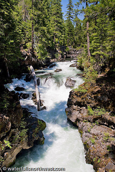
Natural Bridge Falls
Elevation: 3202
feet
Latitude: 42.89 N
Longitude: 122.465 W
USGS: Union
Creek 71/2
Height: 15' Width: 30'
Falls Type:
Cascade
Source: Springs
Stream: Rogue River
Watershed: Rogue River
Best Flow:
Year Round
Facilities
![]()
![]()
![]()
![]()
![]()
Information
Natural Bridge Falls is a
minor cascade along the Rogue River immediately below its
namesake Natural Bridge. The Rogue River has occupied a
short lava tube, submerging itself underground for a few
hundred feet, then billowing out and cascading 15 feet over
a jumbled chute. This isn't so much a waterfall as a
violent rapid. It was decided to leave it in as a clarifier
and because its been prominently discussed in Greg Plumb's
"Waterfall Lovers Guide" books.
Location
Natural Bridge Falls is located adjacent to Natural Bridge
and near Union Creek along Highway 62 west of Crater Lake
National Park. The trailhead is located at the Natural
Bridge day use area, a mile south of Union Creek. The falls
are seen from the footbridge leading to the viewpoint of
the Natural Bridge itself.
Photo/Info: Permission of
Northwest
Waterfall Survey
![]()
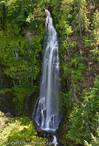
Barr Creek Falls
Elevation: 2443 feet
Latitude:
42.73776 N
Longitude: 122.49524W
USGS: Prospect S.
71/2
Height: 240' Width: 20'
Type: Tiered - 3 Drops
Stream: Barr Creek
Watershed: Rogue River
Best Flows: Spring
Facilities
![]()
![]()
Information
Barr Creek Falls is a
multi-stepped waterfall in the Rogue River Canyon near
Prospect, Oregon. Barr Creek bisects the southern end of
the Prospect Airfield, then drops over a 60 foot fall which
is mostly obscured by trees, then cascades 30 feet and
finally plunges 150 feet to the canyon floor. Barr Creek
doesn't hold a large volume of water, so the falls range
from an explosive torrent during the spring to a more
delicate veil later in the summer. When the flow is right,
a second segment forms adjacent to the final drop of the
falls (it appears on a recent visit that debris has plugged
this channel partially, causing the segment to run dry more
often than not now).
According to Oregon
Geographic Names, Barr Creek was named for the presence of
a cattle bar to prevent cattle from straying out of a ranch
that runs along the creek. The falls were named for the
creek.
Location
Barr Creek Falls
is located just outside of Prospect, off of Highway 62.
Take Mill Creek Road through the town of Prospect to the
Mill Creek Falls Trailhead, about 1 1/2 miles south of
Highway 62. Follow the trail down hill for about 1/2 mile
to its end at an unguarded overlook at the rim of the
canyon.
Photo & Info used by permission of
Northwest
Waterfall Survey
![]()
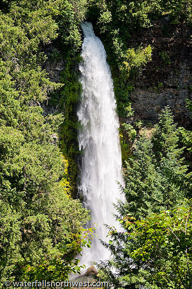
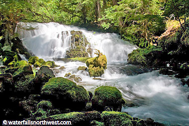
Mill Creek Falls
Elevation: 00 feet
Latitude: 42.74028 N
Longitude: 122.49528W
USGS:
Prospect S. 71/2
Height: 173' Width: 15'
Falls Type: Plunge
Stream: Mill Creek
Watershed:
Rogue River
Best Flows: Year Round
Facilities
![]()
![]()
Information
Mill Creek Falls is the
centerpiece behind the Mill Creek Falls Scenic Area
developed by Boise Cascade just outside of the small town
of Prospect. The falls hurtle 173 feet into the Rogue River
Gorge in an explosive manor, luring eagerly approaching
visitors like a siren in the distance. Though Mill Creek
does exhibit somewhat of a seasonal fluctuation of flow,
the falls don't change their appearance much at all, making
this a good destination any time of the year.
The
town of Prospect was settled in 1882, so it is likely the
falls were discovered around then, but it is not known by
whom or when exactly. Early photographs of the falls were
commonly taken from the bottom of the Rogue River canyon.
Location
Mill Creek Falls is
located just outside the town of Prospect. Following
Highway 62 south from Crater Lake, turn east on Mill Creek
Road about 2/3 of a mile north of the Highway's crossing of
the Rogue River. Follow Mill Creek Road through town for 1
1/2 miles to the marked trailhead. The falls are seen after
hiking slightly less than half a mile down the trail. The
trail system does appear somewhat confusing, so follow what
appears to be an old road if in doubt and listen for the
sound of the falls.
Photo & Info used by permission of
Northwest
Waterfall Survey
![]()
Knob Falls
Elevation: 3040 feet
Latitude:
42.879170 N
122.48611042.87917W
USGS: Union
Crk 71/2
Height: 15' Width: 15'
Falls Type: Punchbowl
Source: Springs
Stream: Rogue River
Watershed: Rogue River
Best
Flows: Year Round
Facilities
![]()
![]()
![]()
![]()
Information
Knob Falls is one of a
multitude of small waterfalls on the upper Rogue River in
the vicinity of Union Creek on the west side of Crater Lake
National Park. The falls occur where the river bends around
a headland, constrict and plunge about 15 feet into a
narrow pool. This may be the most vertical of all the
waterfalls along the Rogue River, but it isn't terribly
noteworthy. If time is a luxury you possess while in the
area, the stroll to the falls is nice and the rocks below
provide good lunch spots, but if you are pressed for time
and want to see the better waterfalls in the area, skip
this one.
Official name is KNOB FALLS. The known Alternate Name is: Lower Natural
Bridge Falls. The name of the falls stems from the large
bedrock "knob" where the river bends sharply. The falls are
referenced in A Waterfall Lovers Guide to the Pacific
Northwest as Lower Natural Bridge Falls.
Location
Knob Falls is located near Natural
Bridge and Union Creek along Highway 62 west of Crater Lake
National Park. The trailhead is located at the Natural
Bridge day use area, a mile south of Union Creek. Find the
Upper Rogue Trail (signed for Woodruff Bridge) and follow
it for just under 1 1/2 miles to the obvious "knob" where
the river bends 180 degrees - a trail follows the
promontory to the falls.
Photo & Info used by permission of
Northwest
Waterfall Survey
![]()
Pearsoney Falls
Elevation: 2481 feet
Latitude: 42.74508 N
Longitude: 122.48954W
USGS Prospect S.
71/2
Height: 12'
Width: 25'
Falls Type: Segmented
Stream: Mill Creek
Watershed: Rogue River
Best Flows: Year Round
Facilities
![]()
![]()
Information
Pearsoney Falls is a small
cascade along Mill Creek about 1/4 mile upstream of the
much more worthy Mill Creek Falls. The falls cascade about
12 feet where the creek splits around a small island - the
majority of the volume of the creek staying to the far side
of the island (the smaller channel may run dry in the late
summer). The falls are worth seeing if planning on hiking
the trail system in Prospect, but focus on the larger
waterfalls downstream first, then only if you have time,
come see this one. Pearsoney Falls was named for a pair of
families who settled in the Prospect area, the Pearsons and
the Mooneys.
Location
Pearsoney
Falls is located just outside the town of Prospect.
Following Highway 62 south from Crater Lake, turn east on
Mill Creek Road about 2/3 of a mile north of the Highway's
crossing of the Rogue River. Follow Mill Creek Road through
town for 3/4 of a mile to the large parking area on the
left side of the road (if you cross the Rogue River you've
gone too far). Follow the trail from the north side of the
parking lot for about 1/5 of a mile to the falls.
Photo & Info used by permission of
Northwest
Waterfall Survey
![]()

Union Creek Falls
Elevation: 3679 feet
Latitude: 42.91917 N
Longitude: 122.3875W
USGS: Union
Crk 71/2
Height: ? Width: ?
Falls
Type: Unknown
Source: Unknown
Stream: Union
Creek
Watershed: Rogue River
Facilities: ?
Information
We do not have ay general
information at this time. If you have some, let us know! See "Add
More Info" at bottom of page.
Location Looking for directions, see map.
![]()
Butte Falls
Elevation: 2358 feet
Latitude: 42.545 N
Longitude: 122.56194W
USGS: Butte
Falls 7 1/2"
Height: apx. 10'
Stream:
Big Butte Creek
Watershed: Rogue
River
Best Flows: Spring
Facilities
![]()
Information
Butte Falls is located in Butte falls,
Oregon. In the early 1900's, a water-powered sawmill
situated right at the Falls of Butte Creek led to the
founding of the nearby town of Butte Falls. Today, a
viewing deck overlooks the falls and picnic areas are
featured for visitors to enjoy the scenery.
Butte Falls may be the only community with a cattle guard
at its entrance. When you cross the cattle guard, it is
time to slow down. Don't let the size of Butte Falls
deceive you.
Location
Located
aprx 40 miles northeast of
Medford. To find Butte Falls, turn right off Hwy 62, 4
miles north of Eagle Point, it is a scenic drive up the
Butte Falls Highway aprx 15 miles to the town.
Photo & Info used by permission of
Northwest
Waterfall Survey
![]()
Dillon Falls
Elevation: 1089 feet
Latitude: 42.45806 N
Longitude: 123.02528 W
USGS:
Gold Hill 7 1/2"
Height & Width: Unknown
Falls Type:
Unknown
Source:
Unknown
Stream: Rogue River
Watershed: Rogue River
Best Flows: Unknown
Information
DILLON FALLS is the
Official name of this waterfall. Known Alternate Name is:
Nugget Falls, Hayes Falls, and Tolo Falls. We are currently looking
for more info. If you have some, let us know! "Add
More Info" at bottom of page.
Location Looking for directions, see map.
![]()
Emigrant Creek Falls
Elevation: 3525
feet
Latitude: 42.06 N
Longitude: 122.54861 W
USGS: Siskiyou Pass 71/2
Height - Width: Unknown
Falls Type: Unknown
Source: Unknown
Stream: Emigrant Creek
Watershed: Rogue River
Best
Flows: Unknown
Facilities ?
Information
EMIGRANT CREEK FALLS is the
Unofficial name of this waterfall.
Currently looking for more info. If you have some, let us know! "Add
More Info" at bottom of page.
Location
We believe Emigrant Falls is remotely located halfway
between Emigrant Lake County Recreation Area (North) and
Iron Gate Reservoir to the South. Please Verify.
![]()
Chocolate Falls
Elevation: 3111 feet
Latitude: 42.02222 N
Longitude: 122.63444 W
USGS: Mt. Ashland 7 1/2"
Height & Width: Unknown
Falls Type: Unknown
Stream: UnKnown
Watershed:
Klamath River
Best Flows: Unknown
Information
CHOCOLATE FALLS is the
Official name of this waterfall. It is on private
property, and one has to cross private property to
access.
Location
We believe Chocolate Falls is remotely located halfway
between Mt Ashland and Pilot Rock, near Colestine Rd and
Interstate 5, on private property.
![]()
BACK TO WATERFALLS
Add More Information!
We Can Add More Information to
this page, Click Here and supply
your text info and we will add it in!
Note: SouthernOrenon.com does not provide any
other specific directions or information by phone about
these Waterfalls or Parks, other than what is shown on the
pages.
This Waterfall page is used for general
informative purposes only. Visitors should verify these
locations, facilities and amenities before driving to these
remote region. This information on is
provided to users on an "as is" and "as available" basis without
warranty of any kind either express or implied. We are not responsible for any diving misdirections or info, if any, on this page. See terms page if needed.