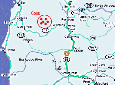
COOS COUNTY WATERFALLS
Powers
area, Coquille River inland from Coos Bay
Coquille River Falls
Elevation: 1313
feet
Latitude: 42.71782 N
Longitude: 124.02073W
USGS Quad: Illahe 71/2
Height: 65' Width: 60'
Type: Tiered- 2 Drops
Stream: Coquille River
Watershed: Coquille R.
Best Flows: Spring
Facilities:![]()
![]()
Information
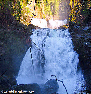
Coquille River Falls is one
of the most consistent waterfalls in all of Oregon. It's
good at any time of year, high volume or low. It's very
photogenic in the summer, and extremely impressive in the
winter. The falls consist of two segmented tiers. The upper
tier drops about 45 feet over a wide, uniform ledge, in
three distinct block-type waterfalls. The lower tier drops
about 65 feet in a pair of concaved horsetails. During the
winter, the lower tier essentially becomes one large wall
of froth, but it's still fairly obvious where the segments
lay. When the Coquille River is running low enough, it's
possible to scale the hillside to the right of the falls,
above Drowned Out Creek, to reach the bottom of the upper
tier of the falls. Small Drowned Out Creek Falls cascades
into the Coquille at the base of the falls.
Coquille
River Falls is the Official name of this waterfall. The
falls were named for the river, which is said to be
pronounced both Ko-Kwell or Ko-Keel. Evidence seems to
point to the word having an Indian origin, but there is a
possible influence from French-Canadian Fur traders as
well.
Location
Located in
Siskiyou National Forest. From city of Coos Bay, follow
Highway 101 south to Highway 42. Go
about 21 miles, and turn right onto the Rogue-Coquille
Scenic Byway, signed for the town of Powers. Follow this
road, which becomes FR 33, for about 38 miles, to FR 3348,
signed for Glendale. Follow FR 3348 for 1 1/2 miles to the
trailhead on the left side of the road. The Coquille River
Falls trail drops moderately steep down into the canyon,
and reaches the falls in 1/2 mile.
Photo/Info: Permission of
Northwest
Waterfall Survey
![]()
Bramble Brush Falls
Elevation: 1104
feet
Latitude: 42.8129 N
Longitude: 124.00253W
USGS Quadrangle: ?
Height: 25' Width: 5'
Falls
Type: Horsetail
Stream: N. Fork Elk Crk
Watershed: Coquille R.
Best Flows: Winter
Facilities:
Bushwack Trail
![]()
Information
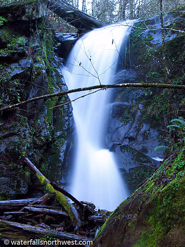
The Elk Creek drainage is
absolutely chock-full of large waterfalls. So far,
Northwest Waterfall Survey has mapped 11 waterfalls on it's
various tributaries. Unfortunately, Elk Creek Falls is the
only one of those that are easily accessed. This is the
only other waterfall that Northwest Waterfall Survey was
successfully able to photograph in the drainage. This
waterfall occurs along the North Fork Elk Creek, just above
FR 3358. Though there is a waterfall mapped in this
vicinity, Northwest Waterfall Survey suspects that it is
not this one, but a larger fall, no more than 1/10 mile
upstream.
Bramble Brush falls is the Proposed name of this waterfall.
Northwest Waterfall Survey named the falls such because
they wanted to convey the moderate frustration they had
while trekking to the falls. Even though it's a mere 200
feet above the road, it took them 10 minutes to
reach because of the thick brush, mostly consisting of
sticker bushes. When the creek is running lower it is
easier to reach.
Location
Located in the Siskiyou National Forest. From
Coos Bay, follow Highway 101 south to Highway 42. Follow
Highway 42 for about 21 miles, turn right onto the
Rogue-Coquille Scenic Byway, signed for the town of Powers.
Follow this road, which becomes FR 33, for 17 miles,
to FR 3358, signed for Big Tree and Cedar Swamp. Follow FR
3358, staying right at the first major junction, for 3 1/2
miles to the crossing of the North Fork Elk Creek. The
falls lay 200 feet upstream of this point.
![]()
Elk Creek Falls
Elevation: 670 feet
Latitude:
42.81496 N
Longitude: 124.01107W
USGS Quadrangle:?
Height: 130' Width: 25'
Type: Tiered-
2 Drops
Stream: Elk Creek
Watershed:
Coquille R.
Best Flows: Spring
Facilities:![]()
![]()
Information
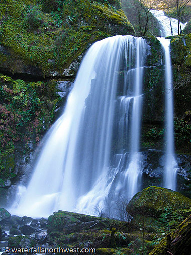
Elk Creek Falls is the
Official name of this waterfall. The Elk Creek drainage is
absolutely chock-full of large waterfalls. So far,
Northwest Waterfall Survey has mapped 11 waterfalls on it's
various tributaries. Unfortunately, Elk Creek Falls is the
only one of those that are easily accessed. On the plus
side, Elk Creek Falls is one of the best waterfalls in the
area. The falls drop over at least two tiers, each about 70
feet tall, with a possible 3rd tier a short distance above,
which may bring the total height close to 200 feet. The
falls are located just off the road, and are accessed via a
barrier free trail, and a picnic table. During the winter,
there are a pair of pretty ephemeral waterfalls in the
area, one just downstream of the trailhead, and one just
below Elk Creek Falls.
Location
Located in the Siskiyou National Forest. From the city of
Coos Bay, follow Highway 101 south to Highway 42. Follow
Highway 42 for about 21 miles, and turn right onto the
Rogue-Coquille Scenic Byway, signed for the town of Powers.
Follow this road, which becomes FR 33, for about 17.7
miles, to the signed trailhead on the left. The trail leads
to the base of the falls in less than 5 minutes.
![]()
Other Falls Include:
Rock Creek Falls
Rock Valley Falls
Coal Creek Falls
Camas Creek Falls
East Fork Falls
Hamilton Falls
Brewster Canyon Falls
Lost Creek Falls
Lost Valley Falls
NO INFORMATION YET
No
Pictures Available.
![]()
BACK TO WATERFALLS
Add More Information!
We Can Add More Information to
this page, Click Here and supply
your text info and we will add it in!
Note: SouthernOrenon.com does not provide any
other specific directions or information by phone about
these Waterfalls or Parks, other than what is shown on the
pages.
This Waterfall page is used for general
informative purposes only. Visitors should verify these
locations, facilities and amenities before driving to these
remote region. This information on is
provided to users on an "as is" and "as available" basis without
warranty of any kind either express or implied. We are not responsible for any diving misdirections or info, if any, on this page. See terms page if needed.