The jewel in the crown has to be
the 68,700 acre Strawberry Mountain Wilderness.
Here, rugged ridgelines and daunting rock faces,
cracked by frost and adorned with red and yellow
lichens, tower above talus slopes and alpine
lakes. Basalt, sandstone and granite rocks show
diversity of color matched only by their
unpredictability of form. Scattered sub alpine
fir and late blooming wildflowers find homes
among rock crevices and thin rocky soils.
Below the ridgeline, the occasional dry,
open ridge or wet meadow is surrounded by stands
of lodgepole pine and subalpine fir, framing
distant views to the expanses of Bear Valley to
the south or the John Day Valley to the north.
Snow fields cling on through mid summer, their
melt waters flowing down through pristine
drainages where waist high columbines and lush
thickets of red alder cast dappled shade on a
creek more easily heard than seen. All types of
wildlife call the Wilderness their home,
offering good chances of seeing a red tail hawk
soar overhead, hearing the bugle of a bull elk
echo across the valley, or glimpsing brown trout
jump in the cool mountain air. While the
Strawberry Mountain Wilderness has an abundance
of visual delights, many other special and
beautiful areas exist around each of the Ranger
Districts of the Forest.
The
Blue Mountain Ranger District has the
Vinegar Hill/Indian Rock Scenic Area, a place
where natural features and processes have
combined to produce diverse landscape patterns.
Upland meadows are divided by clumps and ribbons
of fir, and populated with outcrops of basalt
and granite. Large expanses of burned forest
stand with silver and black stems, needles and
limbs consumed in one of the many wildfires run
through this area. Below them, green shoots
signify new life and the cyclical process of
life and death in the forest. Much of the rain
and snow in the Scenic Area drains to the Middle
Fork of the John River. Designated as a State
Wild and Scenic River, the Middle Fork flows
through grassy meadows and stands of pine, below
rimrocks and the leap of returning steelhead. In
the heart of the District, Magone Lake
Recreation Area offers camping, fishing and
boating enclosed by majestic "pumpkin" pines,
ponderosas with their deep orange bark and
characteristic black furrows.
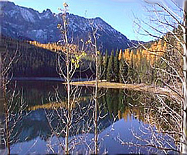
Magone Lake, in the Malheur National
Forest, about 26 miles north of John Day, is one
of Grant County's most popular lakes. Angling
for 8-to 15-inch eastern brook and rainbow trout
is consistently good. The U.S. Forest Service
rebuilt a 22-space campground, a boat ramp, and
covered picnic area near the lake a few years
ago. This area offers swimming, hiking, fishing,
geology viewing, and wildflower viewing.
Magone Lake covers about 50 acres and features
both deep holes (up to 100 feet) and shoals on
the north side. Some of the best fishing is in
the weed beds that cover portions of the
northside shoals. A hiking trail circles the
lake so that people can fish easily from the
shore. A float tube or rubber raft is handy,
especially for fly fishing. Every year brook and
rainbow trout are planted and grow quickly.
Three-pound brookies are caught occasionally.
Magone Lake is open year-round, allowing for
ice fishing for those who ride snowmobiles into
the lake. The ice usually comes off by April.
Access roads are usually snow-free by late May
or early June.
To get to Magone Lake from
the west or northwest, drive south on Highway
395 past Long Creek and turn left on Forest Road
36. The road leads east to the lake. The other
road access, (26 miles north of John Day) is
from Hwy. 26 to County Road 18, then turn onto
Forest Service Road 36, which leads to the lake.
A Malheur National Forest map would be helpful
and can be found at Forest Service offices in
John Day and Prairie City and at sporting goods
stores.
For more information about road
conditions, or to reserve the group campground
(it accommodates about 20 people and has room
for motor homes or fifth-wheels) or the picnic
shelter, call the Blue Mountain Ranger District
at (541) 575-3000. There is drinking water, and
each space features a picnic table, fire ring
and cooking grate. There is no electricity or
garbage collection.
Monument Rock
Wilderness at the southernmost edge of
the Blue Mountains, this area's alpine,
once-glaciated ridges offer views across much of
eastern Oregon. This Wilderness can be accessed
from Prairie City via County Road 20 and Forest
Road No. 13 and 1670. The lichen-covered 8-foot
cylindrical stone monument atop Monument Rock
may have been erected by pioneer sheepherders.
This is a new Wilderness in the old landscape of
the eastern Strawberry Mountains. Established in
1984 by the Oregon Wilderness Act, the
19,620-acre Wilderness spills from the Malheur
National Forest onto the adjacent
Wallowa-Whitman National Forest. The northern
end of the area lies across a watershed divide
that separates drainages of the South Fork Burnt
River, as well as two National Forests. The area
ranges from about 5,200 feet in the lower
regions to the 7,815-foot top of Table Rock.
In the lower lands you will find ponderosa
pine, depending on where you go. You may also
find lodgepole pine, Douglas-fir, white fir,
aspen, and juniper. If you look down, you will
probably see elk sedge, pinegrass, wheatgrass,
huckleberry, bluegrass, and many wildflowers. As
you hike higher, you will find subalpine fir,
just below the treeless mountain crests.
The area's diverse wildlife habitat is used by
bear, deer, elk, badgers, and the rare
wolverine. There are 70 species of birds
including the creek-loving water ouzel (American
dipper) and the pileated woodpecker.
The
visiting season here generally runs between June
and November. The John Day Valley funnels winter
storms and summer thundershowers to the mountain
ridges here. As a result the area receives 40
inches of annual precipitation, twice as much as
the surrounding, arid lowlands. Summer brings
hot days and chilly nights. Hunting is the most
popular activity, with hiking and backpacking
increasing in popularity. Table Rock Lookout
draws many visitors and is one of the entry
points to the Wilderness.
Table
Mountain - The fire lookout tower on
Table Mountain is a good place to begin a visit
to the Monument Rock area. After taking in the
view, backtrack a half mile down the lookout
road and take a level 2-mile stroll along an
ancient dirt road to Bullrun Rock's 150-foot
cliffs. A fork of this trail winds close to
Monument Rock and continues 5 miles along a
scenic ridgecrest to Lone Rock. To reach the
trailhead from Prairie City, turn south from
Highway 26 on Main Street, follow a paved road
southeast 9 miles, turn left onto Road 13 for 12
miles, then take Road 1370 to the left.
The Bullrun Creek Trail starts
out with 2 easy miles of hiking in a steep-sided
canyon, but then climbs 2000 feet in 3.5 miles
up a ridge to Bullrun Rock. Drive to the
trailhead from Highway 26 by heading west from
downtown Unity on a paved road for 1 mile, then
turning left onto gravel road for 4 miles. Jog
to the right on Road 1695, then follow Road 210
to the trail.
Starvation Rock
- One of the more accessible and popular hikes
climbs past Starvation Rock, a large basalt
monolith, to Road 548 on the narrow ridge
between Sheep Rock and Lookout Mountain.
Backpackers and equestrians can use this path as
a connector between the Glacier-Monument and
Strawberry Mountain trail systems, which are
less than 2 miles apart here.
Aldrich Mountains - Snow capped in
winter and catching the suns early morning rays,
the Aldrich Mountains loom over the John Day
Valley like a row of pyramids. This large
roadless area has expansive open ridgetops and
dense timbered drainages where large Douglas fir
and ponderosa pine can be found. To the south,
Murderers Creek wanders through a flat valley,
past pine forest, scattered meadows and
occasional ranch buildings, then drops through
the gorge around Shake Table with its dramatic
canyon walls and rimrocks. Similarly, parts of
Deer Creek and the South Fork of Murderers Creek
contribute to the scenic beauty of the District,
winding through narrow, constricted v-shaped
valleys with lush riparian shrubs and rocky
outcrops, or through open grassy meadows
surrounded by large ponderosa pine where horses
- wild and domestic - graze lazily.
Prairie City Ranger District
has areas with dramatic scenery and sublime
beauty. In the Monument Rock Wilderness timbered
slopes give way to open ridgetops where, at your
feet, hardy Indian paintbrush compete for your
attention with distant views of forested
mountains and sagebrush flats. Logan Valley,
with the south face of the Strawberry Mountains
as a backdrop, has changing scenes through the
year. Carpets of spring wildflowers, swaying
summer grasses, and autumnal aspens with
orange-yellow leaves atop white bark stems, have
made this a special place for hundreds of years.
The North Fork of the Malheur River, a Federal
Wild and Scenic River, certainly lives up to
this description. Flowing through open meadows
on the floor of this steeply walled valley, some
of the Forests largest ponderosa pines reflect
in the cool running water. As the river flows
southward, valley becomes canyon, and outcrops
of basalt and loose talus slopes intersperse
with dry open forest and sagebrush hills. The
distinct cry of an osprey may be heard over the
riffles of the water.
Whatever kind of
scenery appeals to you, the Malheur National
Forest has something that will enable you to
leave here with a great photograph, a fond
memory and a desire to return.
For more info Call: Harney County Chamber Of
Commerce 541-573-2636
Add More Information!
We Can Add More Information to
this page,
Click Here and supply
your text info and we will add it in!
BACK TO LAKES PAGE This
is a general information page. All lake information on is
provided to users on an "as is" and "as available" basis without
warranty of any kind either express or implied.
SouthernOregon.com is not responsible for any change in lake
information, conditions, amenities, misprint, hours or
directions. See
terms page to read more user details.