NORTH UMPQUA RIVER AREA
From
Roseburg/Glide along Umpqua Hwy 138. Other areas are listed throughout this page.
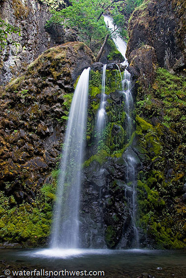
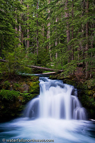
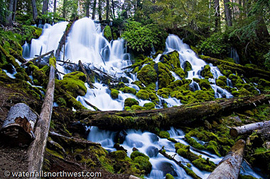
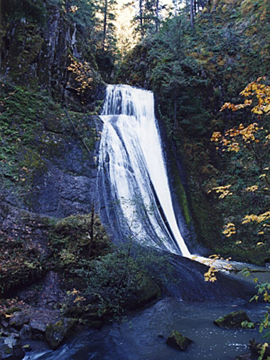
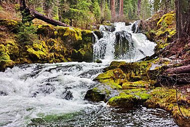
Fall Creek Falls
Elevation: 1361 feet
Latitude: 43.31889 N
Longitude: 122.83972W
USGS Mace Mt. 7 1/2"
Height: 120' Width: 15'
Type: Tiered 3 drops
Stream:
Fall Creek
Watershed: Umpqua R.
Best Flows: Spring
Facilities
![]()
![]()
![]()
Information
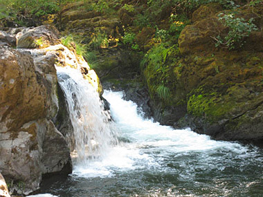
Fall Creek Falls is one of
the more accessible waterfalls in the North Umpqua
corridor. Dropping about 120 feet over 4 tiers, the falls
spray into a small amphitheater before cascading down
through a very scenic gorge to the Umpqua. The falls
consist of four tiers, of approximately 10, 40, 20 and 50
feet - with the uppermost tier only being visible from the
top of the falls. The falls were apparently measured by the
Oregon Fish and Wildlife Service at 197 feet tall, however
that appears to be a significant overestimate.
Location
Fall Creek Falls is located east of
Glide along the North Umpqua Highway. From Glide, head east
to milepost 32 and the well signed Fall Creek picnic area
and trailhead. The trail winds an easy 3/4 mile to the
falls, passing several pretty cascades and a rock outcrop
known as Jobs Garden. The falls can also be accessed from
FR 4710.
NOTE
This Fall trail is closed due to damage from the Archie
Creek Fire. Trail reopening are unknown at this time.
We
would appreciate anyone letting us know when it re-opens so
we can repost info.
Photo/Info: Permission of
Northwest
Waterfall Survey
![]()
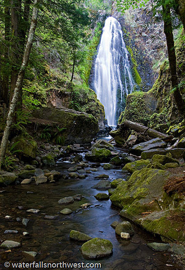
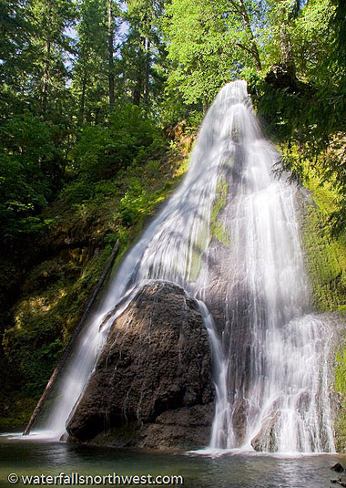
Susan Creek Falls
Elevation: 1084 feet
Latitude: 43.305 N
Longitude: 123.00158W
USGS: Old
Fairview 71/2
Height: 35' Width: 10'
Falls
Type:Unknown
Source: Unknown
Stream: Susan Creek
Watershed: Umpqua R.
Best Flows: Spring
Facilities
![]()
![]()
![]()
![]()
![]()
Information
Photo shows Susan Creek
Falls from the footbridge. Susan Creek Falls is a pretty,
but fairly lackluster 35 foot veil along the
waterfall-studded Umpqua River corridor. The falls are
accessed via a very easy, well graded trail developed and
maintained by the Oregon BLM. The falls face south and will
see best lighting in the morning and evening. Picnic tables
are provided below the falls for a nice afternoon
destination for a family outing. For serious waterfall
hunters, I would definitely suggest dropping this one down
the priority list a few notches in lieu of the much better
waterfalls further into the mountains.
Location
Susan Creek Falls is located 12 miles
east of Glide along the North Umpqua Highway (SR 138). The
parking area is signed, and the trail is graded evenly
enough that it should be accessible to the disabled with
the stamina to make it the 3/4 mile to the falls.
NOTE This
Fall trail is closed due to damage from the Archie Creek
Fire. Trail reopening are unknown at this time.
We would
appreciate anyone letting us know when it re-opens so we
can repost info.
Photo/Info: Permission of
Northwest
Waterfall Survey
![]()
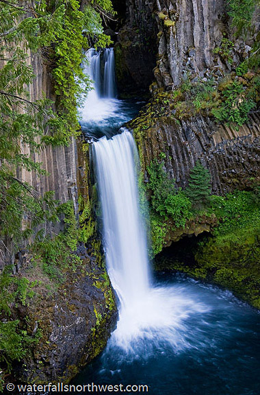
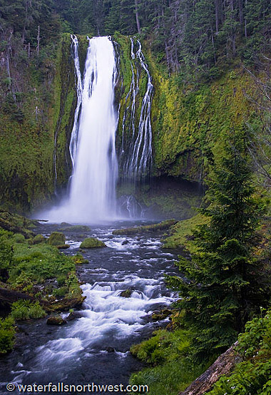
Toketee Falls
Elevation: 2329 feet
Latitude: 43.26306 N
Longitude: 122.43333 W
USGS:
Toketee Falls 71/2
Height: 113' Width: 10'
Type: Tiered- 2 Drops
Source: Springs
Stream: North
Umpqua R.
Watershed: Umpqua R.
Best Flows: Year
Round
Facilities
![]()
![]()
Information
Toketee Falls is one of the
most famous waterfalls in all of Oregon, renowned far and
wide for the graceful columnar basalt formation framing the
two-stepped falls. The North Umpqua River has carved a
sinuous gorge out of the lava flow, resulting in a
waterfall of 113 feet in height - a 28 foot upper tier
which plunges into a pool flanked by a deep alcove,
followed by an 85 foot plunge into a large pool. At the
trailhead, the wooden 12 foot diameter Toketee Pipeline is
passed, which diverts much of the volume of the North
Umpqua River to a powerhouse downstream. This artificial
taming of the river allows the waterfall to flow in an
extremely consistent manor all year long. Toketee Falls is
one of the most photographed waterfalls in southern Oregon
due to its ease of access.
"Toketee"
is a Chinook word meaning Graceful. The irony in this
choice of names continues to baffle me - the falls were
named long before the hydroelectric system was in place,
and the full volume of water of the North Umpqua River was
allowed to flow over the falls in a much less graceful and
much more explosive manor.
Location
The Toketee Falls trailhead can be found 1/2 mile north of
Highway 138 near Toketee Lake, itself about 43 miles east
of Glide or 16 miles west of Diamond Lake. Simply watch for
the road signs. The trail leading to the viewpoint is about
1/3 of a mile in length and while it is not designed for
the disabled, it is well graded and easy to travel.
Photo & Info used by permission of
Northwest
Waterfall Survey
![]()
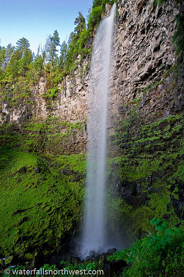
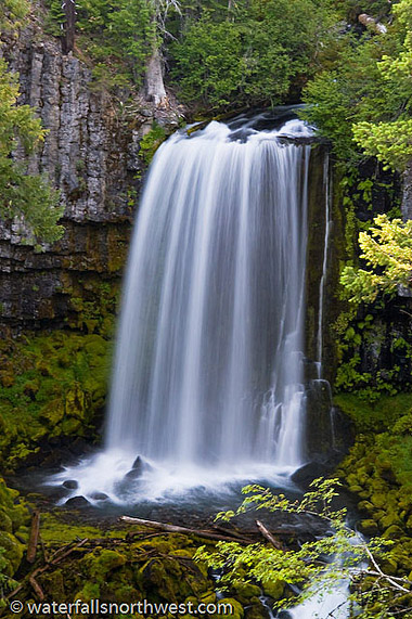
Watson Falls
Elevation: 3214 feet
Latitude: 43.24167 N
Longitude: 122.39083W
USGS Fish
Crk Desert"
Height: 302' Width: 20'
Type:
Plunge- 1 drop
Stream: Watson Creek
Watershed: Umpqua
R.
Best Flows: Spring
Facilities
![]()
![]()
![]()
Information
Watson Falls is arguably the best
waterfall in the North Umpqua River basin. The falls hurtle
over a cathedral amphitheater wall of basalt, crashing into
a long talus slope covered in moss and vine maple. The
falls plunge over enough of an overhang that occasional
gusts of wind can toss the water sideways or upwards in
rare cases (usually later in the summer when there is less
water in the creek). Watson Falls is often referred to as
dropping 272 feet and being the 3rd tallest waterfall in
Oregon. I measured the falls in 2009 to stand 302 feet
tall. This still doesn't push it to the position of 3rd
tallest in Oregon, but it is certainly worthy of the
attention of any waterfall aficionado. Watson Falls is a
favorite location for photographers looking for intimate
water-scapes.
The origin
of the name of the creek is unknown. Watson Mountain in the
Glide area was named for a James Watson, who settled on the
banks of Fall Creek near Glide in 1854. The name may have
been carried over for the same individual. Watson Falls was
likely named for the creek.
Location
Watson Falls can be found
along Fish Creek Road #37, just over 2 miles east of
Toketee Falls and Lake, itself about 43 miles east of Glide
or 16 miles west of Diamond Lake. The parking area is 1/5
of a mile south of Highway 138 on the right side. The trail
crosses Road 37 and climbs easily but steadily up to the
base of the falls in about 1/3 mile.
Photo & Info used by permission of
Northwest
Waterfall Survey
![]()
Whitehorse Falls
Elevation: 3681 feet
Latitude: 43.24778 N
Longitude: 122.305 W
USGS:
Garwood Butte
Height: 14' Width: 10'
Type: Punchbowl
Source: Springs
Stream: Clearwater
River
Watershed: Umpqua R.
Best Flows: All Year
Facilities
*Roadside access
Information
Whitehorse Falls is the
smaller but arguably prettier of the two named waterfalls
along the Clearwater River. The falls occur where the river
sluices through a narrow trough in rhyolitic bedrock and
suddenly crashes 14 feet over a wall into a large pool
below. Though the falls are located several miles
downstream of Clearwater Falls, there is often less water
present in Whitehorse Falls due to the integration of the
river in the North Umpqua Hydroelectric system. The flow is
consistent all year long, just not in tune with its natural
levels nearly as much as it should be. When I visited the
falls most recently in 2007, it appeared the Forest Service
was rebuilding the viewpoint to be wheelchair accessible.
Whitehorse is a fairly straightforward waterfall to
photograph, in more senses than one. Most people will aim
down and focus on the falls and the pool, but the trees
around the falls are equally impressive and vertical
compositions to accentuate the trees work equally well, if
not better. The falls face west and are in a heavily
forested area. Mid day will yield bad contrast but late
afternoon or early morning won't present problems.
Location
Whitehorse Falls are situated
within the Whitehorse Falls Campground, located 4 1/2 miles
east of Tokatee Lake (or 63 1/2 miles east of Roseburg)
along Highway 138. The parking area is encountered before
the campground and the falls are visible immediately
adjacent.
Photo & Info used by permission of
Northwest
Waterfall Survey
![]()
Lemolo Falls
Elevation: 3708 feet
Latitude: 43.34566 N
Longitude: 122.22002W
USGS
Lemolo Lake
Height: 165' Width: 25'
Type:
Horsetail-1 Drop
Source: Springs
Stream: North
Umpqua R.
Watershed: Umpqua R.
Best Flows: All Year
Facilities
![]()
![]()
![]()
Information
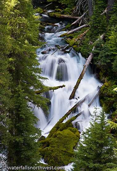
Lemolo Falls is both the
tallest and most powerful waterfall along the North Umpqua
River. Here the river breaks over a contorted cliff of
columnar basalt and plummets 165 feet into a large pool.
The falls have been described as a raucous monster - its
name even adding to that reputation - yet Lemolo Falls is
actually one of the most consistent waterfalls in Oregon.
The Lemolo Lake Dam a few mile upstream draws off the vast
majority of the North Umpqua River but allows a fixed
amount of water to flow over the falls at all times. The
only time when the river is allowed to flow freely is at
the peak of snowmelt when the diversion channels are maxed
out and when the lake is drawn down. It is an impressive
waterfall to see at high water - the entire cliff turning
into a wall of explosive spray some 60 feet wide - but even
under standard conditions, this is still a very impressive
waterfall. The Forest Service cites the falls as being 102
feet tall in places, however the 1998 USGS Lemolo Lake
quadrangle clearly marks this waterfall as dropping 165
feet and I'm much more inclined to believe that figure.
Lemolo is a Chinook Jargon word meaning "wild" or
"untamed", which has its origins in the French "le moron",
which itself is a bastardization of "marron", which refers
to a runaway black slave.
Location
Lemolo Falls is located near Lemolo and Diamond Lakes in
the Umpqua National Forest. Depart Highway 138 eleven miles
east of Toketee at FR 2610, marked for Lemolo Lake. Follow
Road 2610 for 4 1/4 miles and turn left onto Thorn Prairie
Road # 3401. Follow 3401 for 1/2 mile to Road 3401-800 (a
small sign reads just "800"), and a sign pointing towards
Lemolo Falls. Follow 800 for 1 3/4 miles to road # 3401-840
(again, signed just "840"), also marked for Lemolo Falls.
Proceed to this road's end in 1/4 mile. Lemolo Falls trail
# 1468 takes off downhill, following part of an old road to
the old trailhead and picnic area in 1/3 mile. The falls
are reached 1 mile from the trailhead.
Photo & Info used by permission of
Northwest
Waterfall Survey
![]()
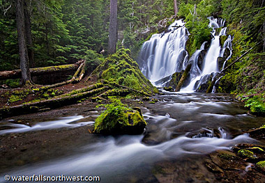
Warm Springs Falls
Elevation: 3501 feet
Latitude: 43.35773 N
Lng: 122.24339 W
USGS:
Lemolo Lake
Height: 60' Width: 35'
Type:
Curtain- 1 Drop
Source: Springs
Stream: Warm Springs
Ck
Watershed: Umpqua River
Best Flows: Year Round
Facilities
![]()
![]()
*Viewpoint
Information
Warm Springs Falls is a
remarkably consistent 60 foot waterfall where its namesake
creek thunders over a columnar basalt formation into a
mossy amphitheater below. We are unaware of the stature of
the springs which feed the creek. We have heard they
installed a viewing deck as well as upgrade the trail to
allow wheelchair access (please verify). The Warm Springs
Falls Trail has the added bonus of being lined with lots of
wild Rhododendron, usually blooming in June and early July.
Location
Warm Springs Falls is
located near Lemolo and Diamond Lakes in the Umpqua
National Forest. Depart Highway 138 eleven miles east of
Toketee at FR 2610, marked for Lemolo Lake. Follow Road
2610 for 5.2 miles, crossing the Lemolo Dam along the way,
and turn left on Road 600. Drive for 3 miles to Road 680
and turn left. Proceed down this route for 1.7 miles to the
Warm Springs Falls Trail #1499. With the redevelopment in
2007, the falls to should be signed. The trail leads to the
viewpoint in 1/3 mile.
Photo & Info used by permission of
Northwest
Waterfall Survey
![]()
Steamboat Falls
Elevation: 1427 feet
Latitude: 43.37366N
Lng: 122.64068W
USGS: Steamboat
Height: 20' Width: 35'
Type:
Block- 1 Drop
Stream: Steamboat Ck.
Watershed:
Umpqua R.
Best Flows: Spring
*Swimming, Boating.
Facilities
![]()
![]()
![]()
![]()
Information
Steamboat Creek curtains
over a wide bench into a calm pool. In the winter the 20
foot falls are rather impressive thanks to the large
drainage basin of Steamboat Creek, but the low elevation
limits the high flow to only the wettest months, and by May
the falls are a shadow of their former self. This would be
a slightly more impressive attraction in the summer if a
fish ladder, which draws off a majority of the creek,
weren't constructed next to the falls. All around the falls
are exposed rock slabs, which are very popular for cliff
jumping and sunbathing. However, people seem to easily
become unaware of the dangers of waterfalls. I witnessed
several people fording the creek immediately above the
brink of the falls, a fall from which could be fatal. If
you feel the need to explore the streambed above the falls,
please cross the creek well above the falls.
The name of Steamboat Creek stems from a phrase from the
heyday of mining in the area. When a mine was spent or a
claim turned out to have been less productive than
expected, one was "steamboated". The falls were presumably named after
the creek.
Location
Drive east
from Roseburg along Highway 138 for 38.5 miles to the
signed Steamboat Creek Road #38 and turn left. Follow Road
38 for 5.3 miles, and turn right onto Road # 3810, signed
for Steamboat Falls and campground. Follow this road for .6
mile to the campground, and enter. Park around site number
5. The falls are visible from the fenced overlook a mere 50
feet from the parking area.
Photo & Info used by permission of
Northwest
Waterfall Survey
![]()
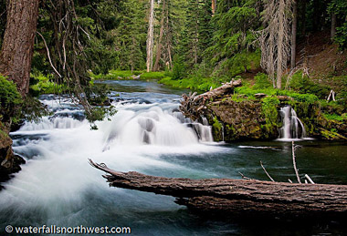
Clearwater Falls
Elevation: 4120 feet
Latitude:
43.24889 N
Lng: 122.22778 W
USGS: Diamond Lake
Height: 29' Width: 35'
Type: Segmented
Source: Springs
Stream:
Clearwater R.
Watershed: Umpqua R.
Best Flows: All
Year
*Roadside Access
Information
High up
in the Umpqua River drainage, the spring fed Clearwater
River bubbles out of the ground and starts flowing through
placid pools and never ending logjams. The first real
interruption in the course of the Clearwater is this
exceptionally scenic but not terribly impressive 29 foot
cascade. The ground around the falls is permeated with soft
soil and thousands of intertwined roots, allowing the river
to seep in and out of the ground at will. The result is a
waterfall that appears to be springing from the ground.
While there is only about 10 feet of legitimate vertical
waterfall here, this is one of the few cases where we bend
the rules to allow the mossy cascades below the falls to be
included as part of the falls, largely because the river is
dead calm both above and below, and it is easy to identify
where the falls begin and end. As mentioned, the Clearwater
River is spring fed, and is one of the most consistent
streams in the northwest in terms of flow, so visiting any
time of the year will yield more or less the same results.
Location
Situated within
the Clearwater Falls Campground, located 8 miles east of
Toketee Lake (or 67 miles east of Roseburg) along
Highway 138. The falls are about 100 feet away from the
parking area.
Photo/Info: Permission of
Northwest
Waterfall Survey
![]()
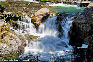
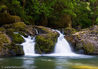
Deadline Falls
Elevation: 801
Latitude: 43.33017 N
Longitude: 123.00158W
USGS:
Glide 7 1/2"
Height: 12' Width: 75'
Falls Type:
Block
Source: Springs
Stream: North Umpqua R.
Watershed: Umpqua R.
Best Flows: All Year
Facilities
![]()
![]()
![]()
![]()
![]()
Information
Photo shows Deadline Falls
just off the North Umpqua Trail. Although the largest of
the small cascades, it really doesn't compare in size to
other falls in the area. It is where the North Umpqua River
cascades over smaller outcrops of the basalt riverbed.
Deadline Falls is one of the best places in Oregon to
photograph fish large Salmon leaping the falls as they
migrate upstream from May to October. The falls face west
and have a broad exposure, so sunlight will light the scene
fairly evenly, where the North Umpqua River cascades over
smaller outcrops of the basalt riverbed.
Photo & Info used by permission of
Northwest
Waterfall Survey
![]()
LITTLE RIVER AREA
Heading South from Glide to Little River & Cavitt Creek.
Shadow Falls
Elevation: 2183 feet
Latitude: 43.15218 N
Longitude: 122.9499 W
USGS: Red
Butte 7 1/2"
Height: 75' Width: 5'
Type: Tiered- 3 Drops
Stream: Cavitt Creek
Watershed: Umpqua
R.
Best Flows: Spring
Facilities
![]()
![]()
Information
Shadow Falls is a rather
aptly named waterfall along Cavitt Creek in the Umpqua
National Forest. Cavitt Creek funnels down a narrow gorge
where the creek has scoured several potholes in the
bedrock, twisting into a narrow chasm with a pool at the
bottom. The rock has been scoured such that it appears the
falls drop through a hole in the rock when viewing from
certain angles (there doesn't actually appear to be a
hole).
The falls have been fairly well known for
quite some time, but it isn't known when they were
discovered (likely by loggers). The name stems from the
dark chasm the falls drop into, rarely receiving direct
sunlight.
Location
Shadow Falls
is located in the Umpqua National Forest south of Glide.
From the town of Glide along Highway 138, follow the Little
River Road for 6 1/2 miles to Cavitt Creek Road, turn right
and proceed another 8 miles to the parking area on the
right. The trail drops gradually down to Cavitt Creek and
reaches the falls in a mile.
Photo & Info used by permission of
Northwest
Waterfall Survey
![]()
Grotto Falls
Elevation: 3136 feet
Latitude: 43.25026 N
Longitude: 122.82118 W
USGS
Quadrangle: Mace Mountain 7 1/2"
Height: 80' Width: 20'
Type: Plunge- 1 Drop
Stream: Unnamed
Watershed: Umpqua R.
Best Flows: Spring
Facilities
![]()
![]()
Information
Grotto Falls is one of the
more well known waterfalls in the Umpqua River watershed.
The falls plunge 80 feet in two segments over a deeply
undercut cliff within a dark recess which gives the falls
its name. The cliff behind the falls is punctuated by a
series of small caves at its base. The creek can range from
a small trickle to a small river after heavy snowmelt, in
which case the falls may take on the characteristics of a
'Curtain' type waterfall.
Grotto Falls was named
for the deeply undercut cliffs and the dark recess where
the falls are located. The stream is a tributary of Emile
Creek and is often referred to as being on Emile Creek
itself. Emile Creek was named for Emile Shivigny, a French
settler who homesteaded in the area in 1875.
Location
Drive east from Roseburg to
the small town of Glide, and turn south on the signed
Little River Road. Follow the Little River Road for 16
miles to signed Road # 2703, and turn left. Follow Road
2703, which is generously covered with washboard, for 4.4
miles to Road 2703-150 (signed for Grotto Falls), turn left
again and follow for another 2.2 miles to the trailhead
just beyond the concrete bridge over Emile Creek (note -
there is no sign with "Grotto Falls" labeled, but there is
a trailhead sign). Follow the easy trail up a few
switchbacks to the falls in 1/3 mile.
Photo & Info used by permission of
Northwest
Waterfall Survey
![]()
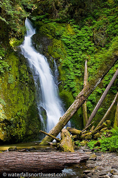
Wolf Creek Falls
Elevation: 1300
feet
Latitude: 43.21828
Longitude: 122.94758W
USGS: Red Butte 7 1/2"
Height: 125' Width: 25'.
Type: Tiered- 2 Drops
Stream: Wolf Creek
Watershed: Umpqua R.
Best Flows: Unknown
Facilities
![]()
![]()
![]()
![]()
Information
During the rainy season of winter and early
spring, the massive upper Wolf Creek Falls puts on a
display of strength and power. Spring brings on lush
vegetation and vibrant colors for photographers. Spring and
early fall, with a light overcast, are considered the best
weather conditions for taking memorable photos. The reduced
water flows in the summer months reveal the delicate and
complex channels and pathways that water has carved into
the bedrock cliffs underneath Wolf Creek Falls. Trail
length: 1.2 miles.
Location
The
trailhead is located 10.7 miles up Little River Road
(County Road 17) which starts from Highway 138 in Glide,
Oregon. There is Arch bridge over Little River at beginning
of trail to falls. A restroom and additional parking are
across the road.
Photo & Info used by permission of
Northwest
Waterfall Survey
![]()
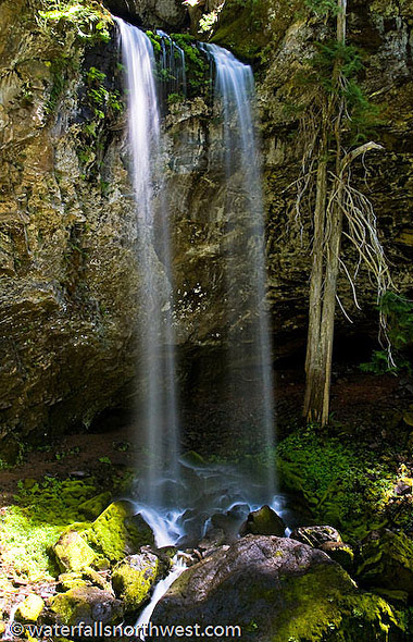
Yakso Falls
Elevation: 3102 feet
Latitude: 43.22453 N
Longitude: 122.71536W
USGS: Quartz Mountain
Height: 50' Width:
25'
Type: Fan - 1 Drop
Stream: Little River
Watershed: Umpqua R.
Best Flows: All Year
Facilities
![]()
![]()
![]()
![]()
![]()
Information
This fine example of a
classic 'Fan' form waterfalls is yet more proof than while
Oregon may not have some of the tallest waterfalls in the
country, it houses some of the prettiest. The infant
stretches of the Little River (truly living up to it's name
at this point) plummets over protruding bulbous rocks,
spreading the water outwards into a small deep green pool.
Because of the way the water is dispersed by the rocks, the
falls look drastically different from different angles. I
recommend visiting this waterfall later in the year, one
because it's a much prettier photography subject in periods
of lower discharge, and two, when the river is higher, it
may not be possible to move around on the rocky beach at
the falls' base without getting wet during the spring melt.
Yakso is a Chinook Jargon word meaning "hair". A rather
fitting name for this waterfall.
Location
Drive east from Roseburg to the small town of Glide, and
turn south on the signed Little River Road. Follow the
Little River Road for 25.8 miles to the signed
Lake-in-the-Woods campground. The trailhead for Yakso Falls
lies directly across the street from the entrance, park in
the campground or along the road. Follow the trail, which
winds amongst towering Evergreens, lacy Vine Maples and
wild Rhododendrons, to the base of the falls in 7/10 mile.
Photo & Info used by permission of
Northwest
Waterfall Survey
![]()
Hemlock Falls
Elevation: 2797 feet
Latitude: 43.21623
N
Longitude: 122.72866W
USGS Quartz
Mountain
Height: 45 feet
Width: 5 feet
Type: Horsetail
Source: Lake
Stream:
Hemlock Creek
Watershed: Umpqua R.
Best Flows: Spring
Facilities
![]()
![]()
![]()
![]()
![]()
Information
Hemlock Creek crashes and
twists about 45 feet down a rugged chasm and into a gorge
covered with mosses, ferns, bushes and trees. The greenery
surrounding the falls is nearly as impressive as the falls
themselves. The gorge below the falls also seems to be a
magnet for fallen trees, as there are several lying
directly in front of the falls, and uncountable numbers
below the falls (though they add to the character of the
area). Though the falls are certainly a notable feature in
the area, it surprised me to learn that there is a
waterfall of at least twice this size not too far upstream
that doesn't sport a name, despite its superior stature.
The Hemlock Falls trail leaves from the Lake-in-the-Woods
campground, who's namesake lake has an interesting back
story. The area the lake encompasses was formerly a small
pasture, which was filled when a nearby stream was
diverted, and used as a watering hole for passing pack
trains. Fortunately, this had no impact on Hemlock Creek or
it's falls.
Location
Drive east from Roseburg to
the small town of Glide, and turn south on the signed
Little River Road. Follow the Little River Road for 25.8
miles to the signed Lake-in-the-Woods campground. The
trailhead lies about 1/3 of the way around the lake (marked
by a generic hiking trail sign). The wide, well graded, but
steep trail leads down to the base of the falls in 1/2
mile.
Photo & Info used by permission of
Northwest
Waterfall Survey
![]()
Cavitt Falls
Elevation: 1051 feet
Latitude: 43.19978 N
Lng: 123.02177 W
USGS:
Lane Mountain
Height: 8' Width: 15'
Type:
Cascade-1 Drop
Stream: Cavitt Creek
Watershed:
Umpqua R.
Best Flows: Spring
* Easy Access
Facilities
![]()
![]()
![]()
![]()
Information
Cavitt Falls is modest
little cascade along Cavitt Creek located within a BLM
campground near Glide. The falls consist or one or two
channels depending on how much water is in the creek, and
drops all of about 8 feet into a large pool (great
swimming). I'm fairly certain there are probably half a
dozen or more larger waterfalls elsewhere on Cavitt Creek
that would be more interesting. Bottom line is this one is
of minimal interest outside of having a great swimming
hole.
Away from the busier North Umpqua corridor,
Cavitt Creek Falls Recreation Site is a favorite of the
locals. This 10 site campground is surrounded by a forest
of fir, maple, and oak trees. A popular day-use area with a
large swimming hole sits at the base of a 6-foot waterfall
on Cavitt Creek and is a welcome highlight on a hot day.
Trout fishing is open from May 22 - Sept 15 on Cavitt Creek
and nearby Little River with artificial flies and lures
only. There is a campground host on site I believe small
fees may imply. Firewood is available for $5 a bundle. Dogs
are allowed on a 6 foot leash in the campground, but are
not allowed in the day-use area or swimming hole.
Location
In the town of Glide, turn
south off of Highway 138 on the Little River Road and
follow it for just over 6 1/2 miles to Cavitt Creek Road (Newbridge
Road works too, as they both merge). The Cavitt Falls
Campground can be found another 3 1/2 miles down Cavitt
Creek Road. The falls are found at the bottom of a set of
stairs from the day use area.
Photo & Info used by permission of
Northwest
Waterfall Survey
![]()
SOUTH UMPQUA RIVER AREA
From South Umpqua River Heading South to Tiller.
Campbell Falls
Elevation: 1425 feet
Latitude: 43.0523 N
Longitude:
122.77073W
USGS: Dumont Creek
Height: ? Width: ?
Falls Type: ?
Stream:
Umpqua River
Watershed: Umpqua R.
Best
Flows: ?
Facilities
???
Information
We do not have ay general
information at this time. If you do, let us know! See "Add
More Info" at bottom of page.
Location
South Umpqua Rd, Nat For Dev
Rd 28 Trail# 1587. There is a sign on the road
that says Campbell Falls. The trailhead is located at a
turnout in the road. The trail is fairly short maybe .25 of
a mile and would probably be between an easy and a moderate
hike. In August, there was lots of poison oak along the
outside of the trail so be careful. Trail# 1587
Photo & Info used by permission of
Northwest
Waterfall Survey
![]()

South Umpqua Falls
Elevation: 1644 feet
Latitude: 43.05444 N
Longitude: 122.68611 W
USGS: Acker Rock 7 1/2"
Height:? Width: ?
Falls
Type: Cascade
Stream:
S Umpqua River
Watershed: Umpqua R.
Best
Flows: ?
* Easy Access
Facilities
![]()
![]()
![]()
Information
This falls results in a
unique formation on the South Umpqua River, where shallow
water flows over a wide slab of bedrock and plunges 15 feet
into a deep pool. An observation deck overlooks the falls
and a fish passage ladder. Trespassing on the fish ladder
is prohibited by state law. The picnic area is popular
during the summer and is managed as an �alcohol free�
recreation site.
Location
Take
I-5 to Canyonville (Exit 98), and County Road 1 east 26
miles to Tiller. At Tiller, take County Road 46, which
becomes South Umpqua Road 28, for a total of 21 miles to
the South Umpqua Falls Picnic Area.
Photo & Info used by permission of
Northwest
Waterfall Survey
![]()
Deer Lick Falls
Elevation: 2279 feet
Latitude:
43.1275 N
Longitude: 122.58389W
USGS
Twin Lakes Mt.
Height: ? Width: ?
Falls Type: ?
Stream: South Umpqua R.
Watershed: Umpqua R.
Best Flows: ?
Type of Access: ?
Information
We do not have ay general
information at this time. If you do, let us know! See "Add
More Info" at bottom of page.
Location Looking for directions, see map.
Photo & Info used by permission of
Northwest
Waterfall Survey
![]()
Cathedral Falls
Elevation: 1241 feet
Latitude: 42.96437 N
Longitude: 122.89311W
USGS:
Tiller 7 1/2"
Height: ? Width: ?
Falls Type: ?
Stream: ?
Watershed: Umpqua R.
Best Flows: ?
Information
We do not have ay general
information at this time. If you do, let us know! See "Add
More Info" at bottom of page.
Location Looking for directions, see map.
Photo & Info used by permission of
Northwest
Waterfall Survey
![]()
HWY 230 AREA
South of Diamond Lake to Hwy 230 heading south.
Ruth Falls
Elevation: 4836 feet
Latitude: 43.08468 N
Longitude: 122.25459W
USGS:
Hamaker Butte
Height: 30' Width: 15'
Type: Horsetail
Source: Springs
Stream: Rogue
River
Watershed: Rogue River
Best Flows: All Year
Access Note:
* Bushwack
* Discouraged Access
Information
Ruth Falls is the first
waterfall one passes along the Rogue River Trail when
traveling downstream from the Mazama trailhead. However, because of the shape of the
canyon and several stands of trees growing mid-slope, the
falls are almost entirely obscured from the trail and are
not easily seen at all. That said, Ruth Falls appears to be
one of the taller waterfalls in this stretch of the river,
dropping a clean 30 feet over a mossy outcropping. The only
viewpoint of the falls that could be found from above
requires descending about 50 vertical feet into the canyon
among crumbly ash slopes with steep vertical drops
immediately below, and it is not recommended that this be
attempted.
Location
Ruth Falls
is located approximately 2 1/2 miles west of the uppermost
trailhead of the Rogue River Trail at the Mazama viewpoint
along Highway 230. It is possible to cut the walking time
in half, however, by driving about 1 1/2 miles west from
the Mazama trailhead, parking alongside the highway, and
walking through the woods to intersect the Rogue River
trail, then hiking about a mile east to where the falls are
audible. Again, we don't recommend attempting to view the
falls from anywhere but on the trail, because the slopes of
the canyon are extremely unstable.
Photo & Info used by permission of
Northwest
Waterfall Survey
![]()
Cascade Creek Falls
Elevation: 4865
feet
Latitude: 43.08806 N
Longitude: 122.25722W
USGS: Hamaker Butte
Height: 75' Width: 3'
Falls Type: Horsetail
Source: Springs
Stream: Cascade Creek
Watershed: Rogue River
Best
Flows: Spring
Facilities
![]()
![]()
Information
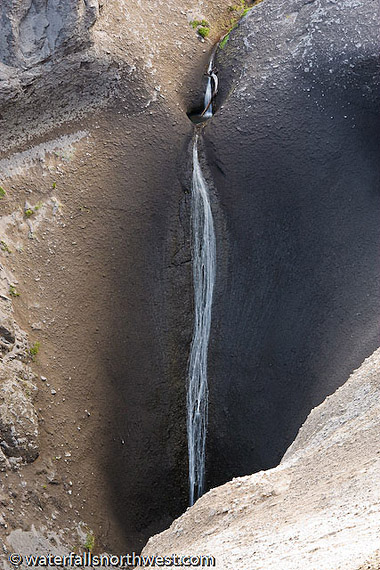
Cascade Creek is a tiny
tributary of the upper Rogue River near Crater Lake in
southern Oregon. The creek heads in a small spring located
just below the Rogue River trail and flows for about a half
mile before gliding about 75 feet down the side of an
impressively expansive canyon cut in the Mazama Ash
formation - a reminder of the areas volcanically violent
past. The canyon as a whole is almost otherworldly with
some very interesting compositions available in the area.
Scouring in the streambed seems to indicate the creek can
move a bit of water during peak snowmelt, but when the melt
has finished, the creek appears to be fed fairly
consistently by the small spring. No reason to think it
dries out at any time during the year.
Location
Cascade Creek Falls is located
approximately 2 3/4 miles west of the uppermost trailhead
of the Rogue River Trail at the Mazama viewpoint along
Highway 230. It is possible to cut the walking time in
half, however, by driving about 1 1/2 miles west from the
Mazama trailhead, parking alongside the highway, and
walking through the woods to intersect the Rogue River
trail, then hiking about 3/4 of a mile east to where the
falls are visible. Best views of the falls require walking
along the canyon rim about 200 feet past where the trail
turns south.
Photo & Info used by permission of
Northwest
Waterfall Survey
![]()
Rough Rider Falls
Elevation: 4399 feet
Latitude:
43.08608 N
Longitude: 122.29045 W
USGS: Hamaker Butte
Height: 30' Width: 10'
Falls Type: Cascade
Source: Springs
Stream: Rogue
River
Watershed: Rogue River
Best Flows: All Year
Facilities
![]()
![]()
Information
ROUGH RIDER FALLS is the
Official name of this waterfall. Known Alternate Name is
Upper Rogue Falls. Oregon's Rogue River contains perhaps
more waterfalls than any other major river in the Pacific
Northwest. Though it isn't the first fall of the Rogue,
Rough Rider Falls is the first waterfall one encounters as
they hike downstream along the Rogue River Trail. Here the
river is pinched between the slowly crumbling and sliding
walls of the canyon and tumbles about 30 feet - the first
20 in a vertical fall - into a very scenic glen seemingly
overgrown in moss. The falls are easy to identify when
coming from upstream - a sign tacked to a tree marks the
falls by name - but those traveling from further down the
river might wander off the trail to the base of the falls
without knowing which of the several small waterfalls along
this stretch of the Rogue has been found. The official
trail doesn't go to the base of the falls, rather climbs up
past it. Scrambling down to the river is easy, but the
ground is steep in a few places and dunking a foot or two
into the cold water is certainly a possibility.
Some
confusion occurs over the placement of this waterfall. Greg
Plumb's Waterfall Lovers Guide cites the fall as Upper
Rogue Falls, but places it too far upstream (at the
location of Rogue River Falls, inaccessible from the Rogue
River Trail). The falls were named in reference to Teddy
Roosevelt and has been in use for some time, but it is not
known who chose the name or when it was first popularized.
Location
Rough Rider Falls is
located approximately 5 1/3 miles west of the uppermost
trailhead of the Rogue River Trail at the Mazama viewpoint along
Highway 230. If the goal is seeing this waterfall itself,
it is possible to cut the walking distance down to about a
mile, however, by driving about 2 1/2 miles west from the
Mazama trailhead, parking alongside the highway, and
walking through the woods to intersect the Rogue River
trail, then hiking about 1 mile west to where the falls are
visible. We don't recommend using this tactic without a GPS
to guide your traverse from the Highway to the trail,
because even though the woods are quite open, its easy to
lose track of where you started.
Photo & Info used by permission of
Northwest
Waterfall Survey
![]()
Muir Creek Falls
Elevation: 4037 feet
Latitude:
43.07417 N
Longitude:122.34389W
USGS Hamaker Butte
Height: ?
Width: ?
Falls Type: ?
Stream:
Muir Creek
Watershed: Rogue R.
Best Flows: ?
Facilities ?
We do not have ay general
information at this time. If you do, let us know! See "Add
More Info" at bottom of page. Looking for directions, see map.
Photo by Fanice S.
![]()
Alkali Falls
Elevation: 5008 feet
Latitude:
43.06856 N
Longitude: 122.36752 W
USGS: Hamaker Butte
7 1/2
Height: 560' Width: 5'
Type: Tiered- 6
Drops
Source: Springs
Stream:
Alkali Creek
Watershed: Rogue River
Best Flows:
Spring
Facilities
![]()
![]()
Information
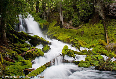
Alkali Falls is a lofty
series of cascades located northwest of Crater Lake. The
falls twist down a long chute-like gully, descending about
560 feet in a run of about 1/10th of a mile. This makes
Alkali Falls one of the 5 tallest waterfalls in Oregon, but
due to the diminutive size of Alkali Creek, it isn't
significant in any way. The first drop is a pretty veiling,
almost vertical descent of about 130 feet. Shortly below,
the creek drops 20 feet then turns almost 90 degrees and
slides down a long incline for about 120 vertical feet. It
then cascades through a short section of boulders, and
enters more slides before ending in a small rocky basin.
The Forest Service has a short trail developed to the base
of the falls, but unfortunately, to see the better sections
of the falls, hiking upstream alongside the falls is
necessary. Maybe one day the trail will be extended.
ALKALI FALLS is the Official name of this waterfall.
Known Alternate Name is: Alkali Creek Falls. Alkali Meadows
was a popular sheepherders camp during the turn of the
20th century, many of the common occupants of which came
from central Oregon where Alkali lakes are common. The name
doesn't reflect the geology of the area, but rather is a
homage to the history of man in the area. The falls were
named for the creek.
Location
Alkali Falls are located about 6 miles northwest of Crater
Lake National Park. From the intersection of Highways 62
and 230 in Union Creek, head north on Highway 230 to the
second junction with FR 6540, approximately 1/4 mile north
of Highway Falls. Follow 6540 for 1/2 mile. Turn right onto
6540-900. Turn left onto Road 6540-950 and follow it to its
end (1 1/4 miles). The trail leads to the base
of the falls in less than 1/10th of a mile. The upper
sections of the falls can be best accessed by crossing the
creek and scrambling upstream along the falls on the north
bank.
Photo & Info used by permission of
Northwest
Waterfall Survey
![]()
Highway Falls
Elevation: 3796 feet
Latitude: 43.03472 N
Longitude: 122.36667 W
USGS
Hamaker Butte
Height: 10' Width: 50'
Falls
Type: Cascade
Source: Springs
Stream: Rogue
River
Watershed: Rogue River
Best Flows: All Year?
Facilities
* Roadside Access
*
Easy Access
Information
Highway Falls is the most
easily accessed of several small to modest waterfalls along
the upper Rogue River in the vicinity of Crater Lake
National Park. The falls occur where the river crashes over
a wide extrusion of basalt about 10 feet tall, turning 90
degrees to its initial angle of flow after the fall. The
cascade can be easily seen from Highway 230 and thusly
enjoyed by all who pass by.
HIGHWAY FALLS is the Official name
of this waterfall. Known Alternate Name is: Lower
Rogue Falls
The name of the falls stems from its
adjacency to the sweeping bend in Highway 230 where the
river kisses the road very briefly then bends away again.
Location
Highway Falls can be seen adjacent to
Highway 230 approximately 5 3/4 miles north of the junction
of Highways 230 and 62 in the town of Union Creek. The
falls are also accessible from the opposite side of the
river from the Rogue River trail.
Photo & Info used by permission of
Northwest
Waterfall Survey
![]()
National Creek Falls
Elevation: 3863 feet
Latitude: 43.03141 N
Longitude: 122.34466W
USGS
Hamaker Butte
Height: 40' Width: 30'
Falls
Type: ?
Source: Springs
Stream: National Creek
Watershed: Rogue River
Best
Flows: Year Round
Facilities
![]()
![]()
Information
National Creek Falls is yet
another among the long list of highly photogenic waterfalls
in Oregon. The falls occur where the spring-fed creek
diverges around a basalt outcropping and plunges about 40
feet over a jagged ledge in two scenic channels. The grotto
below the falls is exceptionally scenic and thriving in
greenery, with a small meadow of mosses growing on a flat
area just downstream of the falls where Falls Creek merges
with National Creek. The falls flow very consistently and
are good to visit any time of the year.
NATIONAL CREEK FALLS is the Official name
of this waterfall. The falls were named after the creek,
but the origin of the name of the stream is not known (It
may originate from the fact that the stream heads within
Crater Lake National Park).
Location
National Creek Falls is located west of Crater Lake
National Park off of Highway 230. The falls are reached by
proceeding 5.8 miles north of the intersection of Highways
62 and 230 to FR 6530. Stay left at the major intersection
and find the trailhead 3 1/2 miles from Highway 230. The
trail drops down to the falls in just under 1/2 mile
Photo & Info used by permission of
Northwest
Waterfall Survey
![]()
BACK TO WATERFALLS
Add More Information!
We Can Add More Information to
this page, Click Here and supply
your text info and we will add it in!
Note: SouthernOrenon.com does not provide any
other specific directions or information by phone about
these Waterfalls or Parks, other than what is shown on the
pages.
This Waterfall page is used for general
informative purposes only. Visitors should verify these
locations, facilities and amenities before driving to these
remote region. This information on is
provided to users on an "as is" and "as available" basis without
warranty of any kind either express or implied. We are not responsible for any diving misdirections or info, if any, on this page. See terms page if needed.