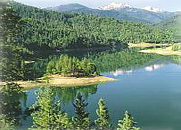
The reservoir provides irrigation and flood
protection for the lower Applegate Valley and enhances the
fishery through maintaining higher and cooler water levels in
the lower river. The Forest Service is responsible for the
maintenance of the 10 campgrounds, viewpoints, and trail system
around the lake. Hart-Tish park, primarily a day use facility
with limited camping, is one of the few Forest Service parks
with several acres of beautifully groomed lawn sloping down to
the water's edge. From Hart-Tish one can look south across the
lake to the peaks of the majestic Red Butte Wilderness.
The following Applegate Lake water level information will be
helpful to those planning to use the various ramps and swimming
areas around the lake. All lake levels are given in feet above
sea-level.
Water Levels Call 800-472-2434, for current lake level
information.
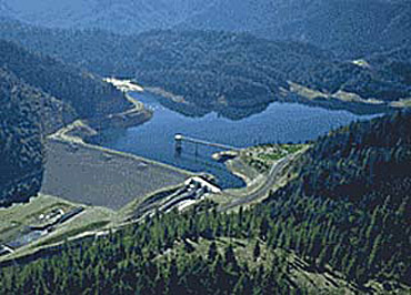
Seven miles up Squaw Creek Road, a
predominantly gravel road across the Applegate Dam, lie Squaw
Lakes.
Click Here to Read more on
Squaw LakesKnown for its
beauty, the Applegate Valley consists of several small
communities. Six miles north of Applegate
Ranger District is Ruch, a small community with an elementary
school, two churches, 2 grocery stores, a service station, three
restaurants, and a small shopping center. Jacksonville, the
nearest community of any real size, with a population of
approximately 2000, is located 14 miles north of the district.
Nineteen miles away in the Rogue Valley is Medford, a full
service community of 46,000. Southern Oregon State College is
located in nearby Ashland.
The town of Murphy is south
of Grants Pass and is located just off Williams Highway where
Murphy Creek meets the Applegate River. It features a market and
several retail establishments along with Hidden Valley High
School, which serves the high school students residing in the
south Rogue Valley, Applegate & Williams Valley areas.
The community of Williams is also in the Applegate Valley and is
located about twenty miles south of Grants Pass. It is a mix of
ranches, rural residences and a town center with several
businesses. It is a wonderful community, known for its artists
and musicians and peace and quiet, accentuated by some of the
most gorgeous scenery in the Rogue Valley.
For
Lake fees, dates,
hours, & info Call 541-899-9220 or visit their website at:
www.applegatelake.com
Add More Information!
We Can Add More Information to
this page,
Click Here and supply
your text info and we will add it in!
BACK TO LAKES PAGE This
is a general information page. All lake information on is
provided to users on an "as is" and "as available" basis without
warranty of any kind either express or implied.
SouthernOregon.com is not responsible for any change in lake
information, conditions, amenities, misprint, hours or
directions. See
terms page to read more user details.