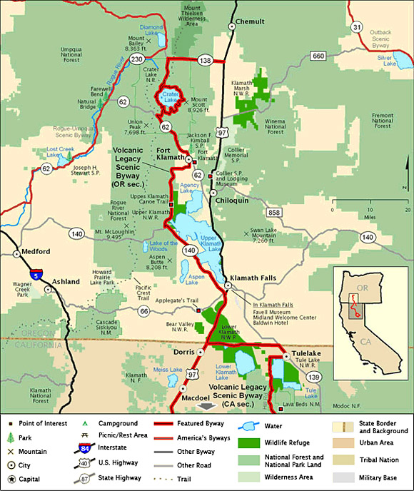
DRIVING DIRECTIONS:
![]() Begin
at Diamond Lake Junction, halfway between Bend
and Klamath Falls on US-97.
Begin
at Diamond Lake Junction, halfway between Bend
and Klamath Falls on US-97.
![]() Take
OR-138 to the north entrance of Crater Lake
National Park (road only open from June through
October).
Take
OR-138 to the north entrance of Crater Lake
National Park (road only open from June through
October).
![]() Travel
the loop around the entire rim of Crater Lake
before exiting the park through the south
entrance and turning left on OR-62.
Travel
the loop around the entire rim of Crater Lake
before exiting the park through the south
entrance and turning left on OR-62.
![]() Continue
west on Weed Road to Sevenmile Road, then follow
West Side Road through the Winema National
Forest. West Side Road connects with OR-• 140 at
Rocky Point.
Continue
west on Weed Road to Sevenmile Road, then follow
West Side Road through the Winema National
Forest. West Side Road connects with OR-• 140 at
Rocky Point.
![]() The
byway continues south as OR-140 meets US-97 two
miles south of downtown Klamath Falls.
The
byway continues south as OR-140 meets US-97 two
miles south of downtown Klamath Falls.
![]() Head
south on US-97 to the California border. (please
note this byway continues south into California)
Head
south on US-97 to the California border. (please
note this byway continues south into California)
Note:
Highlighted byway routes shown on maps of
All-American Roads and National Scenic Byways
correspond to designations made by the U.S.
Secretary of Transportation. State designations
may differ.
Map & Information Courtesy of
National Scenic Byways Online.